Railroad Forums 

  • Framingham and Lowell Branch

  • Discussion relating to the NH and its subsidiaries (NYW&B, Union Freight Railroad, Connecticut Company, steamship lines, etc.). up until its 1969 inclusion into the Penn Central merger. This forum is also for the discussion of efforts to preserve former New Haven equipment, artifacts and its history. You may also wish to visit www.nhrhta.org for more information.
Discussion relating to the NH and its subsidiaries (NYW&B, Union Freight Railroad, Connecticut Company, steamship lines, etc.). up until its 1969 inclusion into the Penn Central merger. This forum is also for the discussion of efforts to preserve former New Haven equipment, artifacts and its history. You may also wish to visit www.nhrhta.org for more information.
 #741158  by eddiebehr
 
I have an 1899 edition of a Geo. H. Walker map showing Metropolitan Parks System and a whole lot more. Plain roads, parkways, street railways, railroads, hills, swamps, etc. It goes out as far as Concord, Burlington, Beverly, Scituate and Sherborn. It places the North Sudbury Station on North Road, which looks a lot like Route 117, a bit west of Nine Acre Corner, Fairhaven Bay and the marshy area that became Andy Boy Farms and is now the Nashawtuc Country Club.
 #741240  by MaineCoonCat
 
Thanks. Much appreciated, however that conflicts with this excerpt from "The history of Sudbury, Massachusetts. 1638-1889" By Alfred Sereno Hudson
The northern branch of the Old Colony Railroad passes through the locality, and has a station which is called North Sudbury. About a half mile southerly of the station is a school-house, and about an equal distance north-easterly is the North Sudbury cemetery. One of the marked changes of this district in the past quarter century is the removal of the " Old Pantry School-House," a place once dear to many an inhabitant now middle aged or already grown old. This schoolhouse formerly stood at the road corners near the Pantry bridge, and was latterly like others of the town, a one-story, white building, with two doors towards the south.
. But, with that said, By measurement "as the crow flies", if I measure 1/2 mile due north of the grade crossing at Haynes Rd. it's dead-center in the above named cemetery... Hmmmmmmmm.

Ah-hah!!! I just pulled up a Maynard topo http://docs.unh.edu/MA/mayn43se.jpg and peering down at the inside of the Y formed by Haynes Rd. and Pantry Rd., it would appear to me it might have been inbetween the two roads, on the southeast side of the tracks as there shows a siding from that point that crosses Haynes Rd. Judging by the photographer's shadow in this Image 
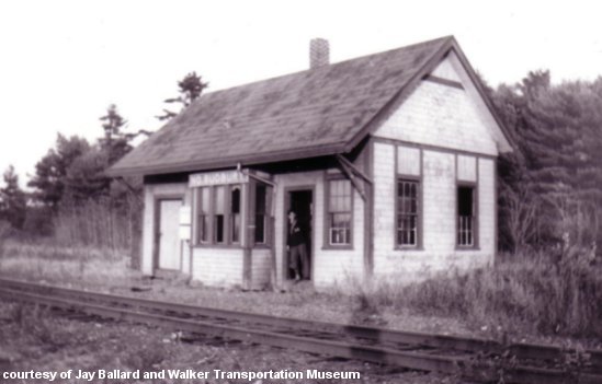
photo. it would've been shot in the afternoon from the Haynes Rd. (southwest - timetable south) end if I'm reading the map correctly (wouldn't be the first time I screwed THAT up!). This photo Image 
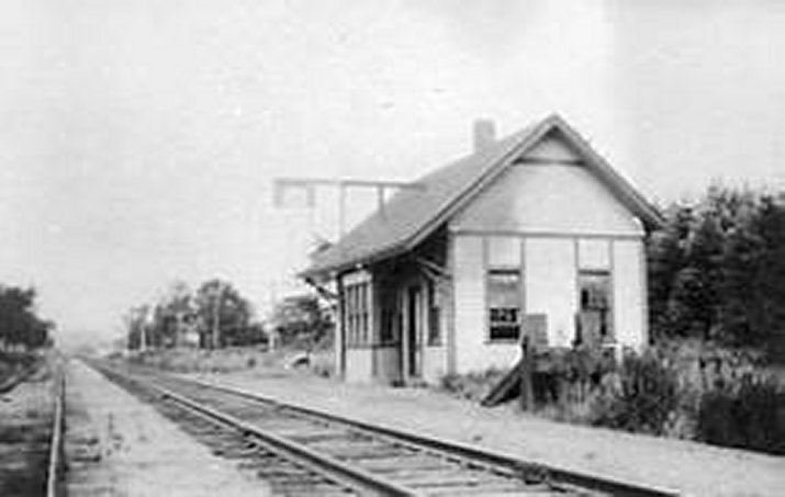
shows the siding in place. I dunno... Thoughts?? All input appreciated.

Photos from: http://www.lightlink.com/sglap3/massach ... burybw.jpg & http://www.lightlink.com/sglap3/massach ... rybwJB.jpg
 #758760  by davidp
 
The February 2010 issue of Trains Magazine has a map showing traffic volumes on the Penn Central in 1969. The F&L branch is depicted in the 1.0 - 4.9 Million anual gross ton range, putting it in the same grouping as the P&W, Attleboro - Braintree, and Canal lines, and ahead of the Fitchburg branch which shows less than 1M gross tons.

Dave
 #813097  by MaineCoonCat
 
Flange Man wrote:Does anyone have any new updates on this branch?
Well the town of Sudbury paved about 50 m/~160 ft of it south of U.S. 20 as part of a sidewalk project on Nobscot Rd...
Other'n that...
 #813321  by davidp
 
Flange Man wrote:Does anyone have any new updates on this branch?
There's a similar discussion thread over on the NE Railfan board...Several weeks ago I posted some pictures of the Rte 2 crossing over there.

Re:

 #1047256  by RussNelson
 
ewh wrote:Regarding trains to Fort/Camp Drum. There is a photo piece in Life magazine from about 1948 about the Maine National Guard (tanks, trucks, and cannon) going to Drum from Portland up the Mountain Division, across Vermont on the St. J & LC to Alburg, on the Rutland to the NYC junction outside Ogdensburg, and the NYC into Drum. Back and forth must have taken up a good part of their two weeks' training! I was at Drum (or Pine Camp originally) back in 1987 and 1988 and all I can say is that you can't do THAT anymore.
Wait a second. What "NYC junction outside Ogdensburg"?? The only junction with the NYC even remotely close to Ogdensburg was in Norwood. The NYC was in Ogdensburg, but from the west and south with no connection to the Rutland from the east.

Re:

 #1047373  by TCurtin
 
RRBUFF wrote:Back in the late 1950's I was in the US Army reserves and we were sent to Camp Drum (Watertown NY) by a strange routing New Haven from the South Boston Dock to Reedville ,Framingham, West Concord to the B&M to Rotterdam Junction to NY Central to Syracuse, and finally to Camp Drum. The return was NY Central all the way to South Station. It was one of the last Troop trains to make that routing.
Do you have any recollection of the motive power or consist, or length of that troop train?

That's a very interesting story to hear. I had long wondered when troop trains stopped going to Camp Drum (now upgraded to "Fort Drum"). I spent the summer of 1971 there as an instructor in the active duty army running classes for the national guard units in their 2-week rotations. Being curious about when that post was served by troop trains, I asked several folks who were long-timers in the area; but nobody had any idea when!

BTW, for those who don't know the geography, Watertown and Camp Drum are on the ex-NYC St. Lawrence Division Syracuse-Massena line

Re:

 #1047374  by TCurtin
 
ewh wrote: Regarding trains to Fort/Camp Drum. There is a photo piece in Life magazine from about 1948 about the Maine National Guard (tanks, trucks, and cannon) going to Drum from Portland up the Mountain Division, across Vermont on the St. J & LC to Alburg, on the Rutland to the NYC junction outside Ogdensburg, and the NYC into Drum. Back and forth must have taken up a good part of their two weeks' training! I was at Drum (or Pine Camp originally) back in 1987 and 1988 and all I can say is that you can't do THAT anymore.
God, what a fascinating collection of routes!!!
There's surely not a piece of that track other then the ex-NYC in the Ogdensgurg-Watertown area that still operates!!
 #1047590  by RRBUFF
 
I was not a railfan then. I think it was 1957. If I recall well it was New York Central Equipment 7 or 8 cars.
 #1047631  by Ridgefielder
 
TCurtin wrote:
ewh wrote: Regarding trains to Fort/Camp Drum. There is a photo piece in Life magazine from about 1948 about the Maine National Guard (tanks, trucks, and cannon) going to Drum from Portland up the Mountain Division, across Vermont on the St. J & LC to Alburg, on the Rutland to the NYC junction outside Ogdensburg, and the NYC into Drum. Back and forth must have taken up a good part of their two weeks' training! I was at Drum (or Pine Camp originally) back in 1987 and 1988 and all I can say is that you can't do THAT anymore.
God, what a fascinating collection of routes!!!
There's surely not a piece of that track other then the ex-NYC in the Ogdensgurg-Watertown area that still operates!!
You're forgetting Conway Scenic through Crawford Notch, and the trackage in Portland itself.

Does anyone know what the last troop train movement *period* over the New Haven was? When did the DoD stop transporting troops by rail?
 #1062853  by Mr Lynn
 
Very interesting thread! We live in the Saxonville section of Framingham. I had not realized that historically there were two different railroads running through Framingham, up to the Penn-Central era, as I discovered in this thread about the B&A and the H. H. Richardson station in Downtown Framingham (formerly South Framingham):

http://railroad.net/forums/viewtopic.ph ... 4#p1062674

About 1995 we thought of moving to a larger house, and looked at one off Edgell Rd (which runs from Framingham Center to Rt. 20 in Sudbury). The rail line (which I now know was the Framingham-Lowell branch of the Old Colony/NH) ran right by it; I thought living next to the track would be great, but as it turned out we decided to enlarge the house we had and stay put. Just as well, as they took up the tracks not long after.

I think at the time there was still service to Sudbury Lumber and maybe north, but I'm not sure.

/Mr Lynn
 #1062895  by MaineCoonCat
 
Mr Lynn wrote:I think at the time there was still service to Sudbury Lumber and maybe north, but I'm not sure.
The STB granted an Abandonment Exemption on October 11, 2001. with the then recent closure of the North Pacific distribution facility (plywood & particleboard). This facility was located about 120 meters (~130 yards) southwest of an interchange track with the Central Mass Branch. This track was where North Pacific's rail activity took place. You can see this on Google Earth at 42°21'46.47"N ▪ 71°25'23.59"W. At the time, this was the sole customer in Sudbury and this was the northernmost point of CSX's activity on the Lowell branch. A 2000 derailment near a town well south of the crossing at the Boston Post Road (U.S. Hywy. 20) did little to inspire local support and pretty much ended service.
 #1063032  by Statkowski
 
Ridgefielder wrote:
TCurtin wrote:
ewh wrote:Does anyone know what the last troop train movement *period* over the New Haven was? When did the DoD stop transporting troops by rail?
Summer of 1965 or 1966. All heavyweight sleepers, mostly Burlington and Northern Pacific. Harlem Rive Branch, heading east (towards Camp Edwards or Fort Devens).

January 1967, for my trip to Basic Training at Fort Jackson, S.C., they tacked five heavyweight sleepers onto the rear of The Palmland (SAL - New York to Miami, local all the way). Penn. Station, N.Y. to Columbia, S.C.
 #1337644  by MaineCoonCat
 
[quote="On June 28, 2015 In an article entitled "Officials Break Ground on Second Phase of Bruce Freeman Rail Trail", Charlene Arsenault of the Sudbury Patch staff"]


Officials Break Ground on Second Phase of Bruce Freeman Rail Trail

When completed, the Rail Trail will be located through several communities, including Sudbury.


Image

By Liz Taurasi (Patch staff)

MassDOT Secretary and CEO Stephanie Pollack joined elected officials and supporters Thursday to celebrate the groundbreaking for Phase 2A of the Bruce Freeman Rail Trail.

When completed, the Rail Trail will be located through the communities of Lowell, Chelmsford, Westford, Carlisle, Acton, Concord, Sudbury, and Framingham, following the 25-mile route of the old New Haven Railroad Framingham & Lowell line. Phase 2A of the Rail Trail project will pass through Westford, Carlisle, and Acton ending at a location just north of Route 2.

“Recognized by the League of American Bicyclists as the fourth most Bicycle Friendly State, Massachusetts’ many cycling initiatives demonstrate our commitment to providing recreational transportation alternatives and healthy living initiatives in the Commonwealth,” said Governor Charlie Baker in a statement issued Thursday. “Expanding the Bruce Freeman Rail Trail will continue that commitment and help to strengthen the quality of life for the families and neighbors in the region and across Massachusetts.”

“The Bruce Freeman Rail Trail stands as the model for how community engagement and innovative thinking can result in the conversion of a rail bed into an active transportation corridor,” said Lieutenant Governor Karyn Polito. “I want to thank the municipal leaders and advocates along the corridor communities for their efforts and congratulate them for reaching this major milestone.”

“It’s exciting to celebrate this project milestone for the Bruce Freeman Rail Trail as we gather here for the groundbreaking today,” said Stephanie Pollack, MassDOT Secretary and CEO. “MassDOT has been working toward incorporating sustainability into all of its activities, from strategic planning to project design and construction to system operation, for one goal: to deliver better services. By working to expand the Rail Trail to Westford, Carlisle, and Acton, MassDOT is showing our support for multi-modal uses such as cycling, jogging, walking and rollerblading.”

The Bruce Freeman Trail is open to multi-modal non-motorized uses such as cycling, jogging, walking and rollerblading. In August 2009, Phase 1 of the shared-use path connecting Lowell, Chelmsford, and Westford was completed. Phase 2A which is comprised of just approximately five miles from Westford, Carlisle, and Acton was advertised in September 2014 and construction is set to begin in July.[/quote]

Read more at the Sudbury Patch's web site