Railroad Forums 

  • Exploring bits of the Meriden, Waterbury & Connecticut River Railroad

  • Pertaining to all railroading subjects, past and present, in New England
Pertaining to all railroading subjects, past and present, in New England

Moderators: MEC407, NHN503

 #1598576  by shepaug
 
Connecticut_railroad_map,_circa_1912.png
Connecticut_railroad_map,_circa_1912.png (28.87 MiB) Viewed 1448 times

Yes..Hamilton Park east---

I am going to have to find the abandonment date of all this stuff.

Wow..excellent pictures from a phone. I seem to see most phones are very low MP but very recent some are getting up there in MP. Just how many digits per ? in the photo etc.

Still available Kodak Cameras. Ebay. I searched for one model I had from old days 14mp and they seem available for about $20. Most seem NEW looking.Don't know about the old electronics and if opened up MICRO-CIRCUITRY. A couple AA rechargeable and ready to go !!! Hard to find cameras that take common battery sizes vs. unique lithium. Anyway...wandering around for years always go good pictures from them.

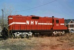
I enjoy old pictures and especially railroad. Look back and where are old pictures ? All the branch lines of railroads etc. RARE. Say...railroads of Waterbury.... Maybe some shots of a passenger train.

When you get the energy snoop the old rail lines heading for Southbury. There was by old maps a cable railroad north of Waterbury.

Watertown railroad station. Destroyed recent times over cost to rehab. (that much ?) Sounds like some rail study by government like $80000 trillion to rehab rail line to Hartford and Terryville Tunnel. I think still an industrial branch after that tunnel eastbound. Going North stub.

Old maps. While surfing might see something new and saw the one I will try to post never seen before. I never saw it and simply shows most older railroads. Just another map.

I do wonder about railroads to Waterbury and Waterbury to Hartford with Guilford gone. There were customers but last I knew a rare paper delivery to newspaper and trash trains from the Watertown stub. Maybe a new operator can solicit something. Some cars from the Ansonia line. Even the propane place there used to use rail and branch very very overgrown.

o-my old slides.. I started review of maybe 30-50 boxes of 20 or more and all look terrible. Literally. I scanned a few a few years ago and pretty good detail etc. Go much worse in last few years ? gughhhhh I am guessing the scanner. Canon 9000f I think it is. Still sell them for about $300 but other places up into thousands. That for a few old slides ? Cheaper to pay somebody probably. Just shots of things late 60's and early 70's. Again..good pictures a few years ago and now terrible. Look like .1 MP etc. --and blops of coming to pieces...
 #1598582  by MACTRAXX
 
SP: Good Connecticut Railroad Historical Map posted...
After looking closely at this map the mentioned date of 1912 is NOT correct - I think this map is MUCH older...
The tip-off to me is parts of the Long Island Rail Road in Suffolk County are not shown...The South Side RR
does not go past Patchogue; The Manorville-Eastport spur off of the Main Line to Greenport terminates at
Sag Harbor - and politically Nassau County is not shown - formed in 1898 when the three eastern townships
of Queens County seceded when the City of New York as we know it today - the five Boroughs/Counties was
formed...Valley Stream, (New) Hyde Park, Hempstead, Hicksville and Oyster Bay are today in Nassau County.
The South Side Railroad along the south shore of LI goes to Breslau - known as Lindenhurst (since 1891)...

Two electrified segments in CT shown - NYS Line to Stamford and New Canaan on the NYNH&H RR only
is something I noticed - Electrification between Stamford and New Haven was new in 1912 as example...

I have handled maps like this when filing paper archive material - I searched the scan for any kind of code or
other mark that can help date this item...I like the coverage that this map has - almost all of New York State
east of the Hudson River from NY City to Albany and almost all of Massachusetts along with Rhode Island...
If I had to guess this CT-based map dates from the second half of the 1880s into the first half of the 1890s...

Good subject and historical topic...MACTRAXX
 #1598647  by CVRA7
 
Every once in a while discussion on this railroad comes to life and it looks like this time we have several dedicated explorers. Several years back the Cheshire Historical Society hosted 3 bus tours - two covered the route from Cheshire west and the other Cheshire east. The tours were conducted by railroad historian Bob Belletzkie who hosts the very informative Connecticut station site Tyler City Station - found at www.tylercitystation.info . For those interested in exploring Connecticut's railroads then and now go to http://www.branchlinepress.com/ and look for the second edition of "The Rail Lines of Southern New England - A Handbook of Railroad History" by Ronald Dale Karr. That's my go-to source of information for subjects like the MW&CR railroad - details like build, operating , out of service and abandonment dates are there, names of operating companies and some equipment rosters. A valuable research tool. The original part of the route was the Meriden and Cromwell Railroad which operated from Center St in Meriden to the Cromwell steamship docks on the Connecticut River. It was chartered in 1883 and completed two years later. Just about the time it was finished another railroad - the Meriden & Waterbury came to life, building a line between a point on the M&C called East Meriden Jct and a point in the south end of Waterbury. The two companies combine to form the Meriden, Waterbury and Connecticut River Railroad and this enterprise sputtered along under various owners eventually ending up owned by the New Haven Railroad. Parts of it were in and out of service starting in 1896, with the outright abandonments starting in 1904 when the line between the Westfield (part of Middletown) and Cromwell was officially abandoned. Many more details can be found in the book.
 #1598648  by CVRA7
 
I'm surprised that "Meriden 3" map shared by Shepaug didn't show the original M&C route from Center St. I'm sure it didn't disappear but maybe it was just thought of as a long siding. The old M&C station became a freight house when the MW&CR was finished and a new passenger station called the West Main St Station was built on the other side of the city. I believe this station also contained the general offices for the railroad and nearby was a small roundhouse and shop. In later years there was one of the final customers - a lumber yard - was also in this area.
 #1599158  by shepaug
 
YEP...very interesting....

If I see an old map try to save it...The above one is new to me I think. It does show most old rail lines and big enough for easy viewing. Long Island..beats me...I wish sometimes they would show lumber railroads etc. Some maps do.

I wish there were more topo type maps. Some site AERIAL? aerial ? Forget now. Some old aerial shots. They put big copyright stuff on it but a free view. Last time there the website was not working right and a total mess. I must have the URL somewhere.
 #1599316  by shepaug
 
Thanks again .... Always enjoy different maps...


Any satellite ones that preserve older years ? I think Google did once. Sometimes they were good at ID of businesses along lines. (if mentioned) Of course 'modern only' assume.

Oddly I had in my possession a government Topo of Bridgeport Ct. of an oddball year that nobody knew existed. Nothing dynamite but an oddity.

Gotta re-check sources of 'track charts' of railroads that ID businesses.

That aerial mentioned above just to mention I am not immune to paying for something but big money to endless different places ?
 #1601208  by shepaug
 
Not to go too far off topic. I did talk about pictures. For years I used Kodak cameras with good results. Then Kodak went under. I see the name re-surfaced and tried one from Ebay and must have been bootleg junk as pictures were terrible..grainy..call it 'noise' ? $100 ? Come on !!

Ebay. Same model I had 14mp. Bought a small collection and all seem new unless somebody hardly ever used it. Uses 2 AA batteries. Use rechargeable

https://www.ebay.com/sch/i.html?ul_noap ... name=11021.

https://www.ebay.com/sch/i.html?ul_noap ... name=11021

Don't come after me if bad luck. Return on Ebay.
 #1602820  by Scalziand
 
Waterbury is gearing up to convert one of the old factory sites along the Mad River and the rail line. The site is technically across the river from the ROW, but might allow a better view of some currently inaccessible parts.

https://wdconline.org/2022/07/21/6-3m-p ... n-october/
https://www.rep-am.com/local/localnews/ ... n-october/