I haven't been there for about 10 years but my dad used to take my brother and I up there once in a while when we were kids. There was still a fair amount left proving their existance, the right of way is still reasonably intact and if it isnt at this point there are still telephone poles, some still with the glass insulators, to mark the way. Concrete footings from a bridge that spanned solomons creek and some concrete buildings and the concrete cable pits still remain. To get there get on PA route 309 north towards mountaintop you will pass the entrance ramps to interstate 81 and soon after see a small restaurant/nightclub (it used to be called Kozy/Cozy K which some websites about the planes will still tell you but now Its called the Brass Rail Restaurant and Saloon you can use mapquest: the address is 2300 Route 309 Ashley, PA 18706) If its still light out there shouldnt be anyone there so you can pull all the way to the back of the parking lot. Then start walking behind the restaurant parallel to the road, there should be a path (local kids still go swimming in "the millie" a pond about 100 yards down) There is a lot of litter on either side. If you continue past the millie which will be at the bottom of a sheer rock slope on your left you will reach solomon's creek and see the footings from the bridge I think there are some logs or rocks or something to get across the creek. Once you get across just walk up parallel to the creek, you should see the telephone poles and then the cable pits and some other remnants. Thats as far as i can remember but im sure there is more. Id check out these photos and maps and try to match them up on Terrafly (which will allow you to zoom to 1.0m resolution
www.terrafly.com), Google Maps and when you visit in person:
http://www.gingerb.com/cnj%20ashley_planes.htm
http://www.northeast.railfan.net/wbmap.gif
http://www.gingerb.com/cnj%20ashley_pla ... me_map.htm
http://www.northeast.railfan.net/local_scene.html
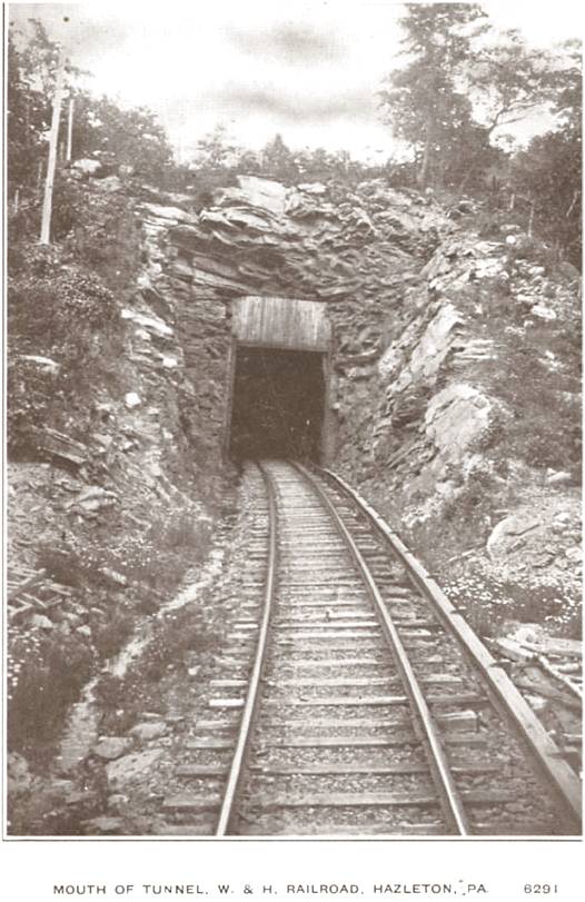
If you dont think thats enough to make it worth your while, the Huber Colliery is within walking distance from the planes, as mentioned above, and the old Wilkes-Barre and Hazelton Rail tunnel south entrance is very close although a little harder to find, but its pretty amazing, cut into solid rock and pretty much unfinished. You can walk in about 500 feet if youre brave and have a good flashlight, but it is blocked shortly past that. To get to the Huber, get to main st in ashley (Hazle st in Wilkes-Barre) and continue past ashley until you see the breaker on your right and a sign for the Earth Conservancy. To get to the WBH tunnel you can continue past the breaker, make a right into the Hanover industrial park at the next intersection (you'll pass a parking lot on the right) at the stop sign make a right and continue all the way through the industrial park (you'll come to an intersection with a light at a main road) turn left there and continue until you turn onto main st in hanover then Mapquest Main st in hanover pa to holly st in warrior run. Park on holly and then walk towards 81 (as I recall there is a still a path where the right of way was that starts near a firehouse or VFW?) Its about a 10 minute walk to the tunnel entrance:
http://www.northeast.railfan.net/images/wbh_tunnel.jpg
And heres a map of the tunnel location (parallel black lines near where the two sides of 81 split):
http://www.northeast.railfan.net/wbhr.gif
I hope this stuff helps, i know from experience that it can be hard to find enough about W-B area railroads.
