Railroad Forums 

  • Quiz...

  • Discussion relating to commuter rail, light rail, and subway operations of the MBTA.
Discussion relating to commuter rail, light rail, and subway operations of the MBTA.

Moderators: sery2831, CRail

 #635888  by jonnhrr
 
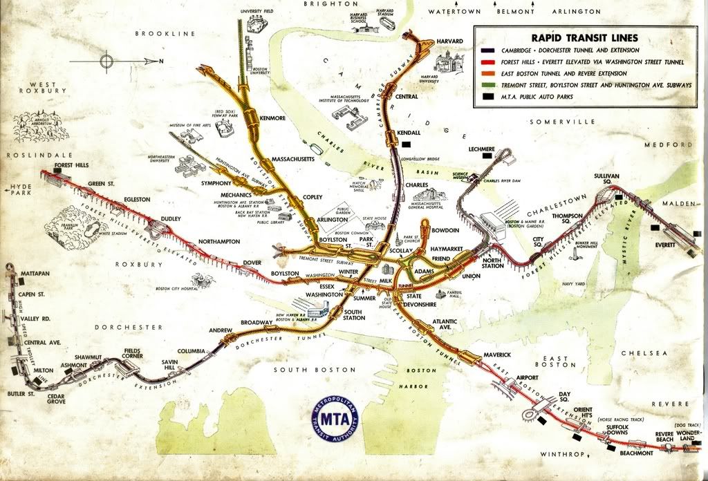
That map (the original one without the Deutsch inspired additions) really brings back memories - the old C-D subway cars had them printed on glass somewhere in the cars I forget where. I seem to recall you could see where they had added on the Revere extension so they must have been fairly old, dating from the BERy days I would guess.

Jon
 #635910  by Gerry6309
 
I believe they dated from he early days of the MTA, and were updated a couple of times. I love the cut-away station diagrams used at some locations. Both overlays and new decals were used as I recall. I believe, (not sure) that the window was first painted with the usual translucent varnish/enamel and then the decal was applied over it.
 #635976  by 3rdrail
 
Those were the best maps that they ever put out ! You get a real feel for the system looking at those. They're also great for viewing the off-set stations and for visualizing the on-ramps to the Elevated sections and transition from the subways.
 #636031  by caduceus
 
Are you referring to this map?

I love this map...maybe I'll dump this into a drawing program and see what I can come up with...

Edit: Ah, I see you had a link to what you drew...for some reason I kept missing the link.

Edit 2: Unfortunately, I just don't seem to be able to draw this thing out to make any sort of sense. I get something of a spiral.

I'm not sure how the "shunts" should appear, or the references to Boylston (as there were two different stations then). I also don't get your connection between Fields Corner and Boylston. But I CAN see that what you came up with could in a way be considered a Moebius loop.
 #636057  by 3rdrail
 
caduceus wrote:I also don't get your connection between Fields Corner and Boylston. But I CAN see that what you came up with could in a way be considered a Moebius loop.
Why that's the Boylston Shuttle - the cause of all this mess ! "...then it dipped down again to join the Cambridge line at Boylston." It finally connected everything outside of the downtown area (Dorchester-Fields Corner). Why just the other night, while coming home from an all-night poker game at Gerry's, I took it and rode with Rod Serling, Isaac Asimov, and Mr. Spock - all the way to Boylston !
 #636087  by Gerry6309
 
Besides the mobius theme, something else on this map has been twisted. Anyone pick this one up?
 #636143  by Gerry6309
 
diburning wrote:North is now east.
Nope! (Hint! Look at your signature)
 #636242  by Gerry6309
 
Yes!

Blue became Red
Red Became Orange
Orange became Blue
And Green is still Green
 #636289  by StevieC48
 
Ok here is one,

Originaly when the Green Line was eleveted between North Sta and Science Park was there a 3rd storage track between North Sta and Science Park Sta???? Gerry and Paul give the youngins a chance before you 2 chime in. :wink:
 #636311  by dieciduej
 
I remember a third storage track just as you make the turn going from North Station eastbound and just before the turn heading into Science Park. I even think I saw some ex-Dallas cars stored there during an event at the old Garden. I would even say they used old third rail stock to make the guard-rails. Not sure when it was cut and pulled up.

JoeD
 #636331  by StevieC48
 
Correct there was a 3rd track at that location ..

One more ? Green Line Everyone is in on this

What was the name of the location of the switch that the North Station Under cars met up with the Lechmere cars and entered the tunnel going towards Haymarket??? Open to all including Paul and Gerry
 #636356  by dieciduej
 
I always knew it as Canal St. Loop, but when the LRVs arrived it became more of a stub.

JoeD
  • 1
  • 2
  • 3
  • 4
  • 5
  • 6
  • 117