Railroad Forums 

Discussion related to commuter rail and rapid transit operations in the Chicago area including the South Shore Line, Metra Rail, and Chicago Transit Authority.

Moderators: metraRI, JamesT4

 #1431501  by Norbert
 
I've been riding the Union Pacific (formely CNW) Westline downtown to work at the Chicago Board of Trade since 1979. On those thousands of trips I've noticed what appears to be a closed/demolished station stop between the current River Forest station stop and the current Oak Park stop. The platform has been chopped off along its length on both sides of the tracks. On the north side there are three or 4 steps still visible that lead from track level up to what was the platform level. This platform is on the north side the UP Westline tracks along Central Ave. in River Forest between Asland and Lathrop. I talk to a woman who grew up in River Forest as a little girl (we're both 60 years old), she said there was never a station there in her lifetime, but there were complete sets of stairs going from street level up to the platform and that she personally used to play on those stairs as a child. She said that the stairs from street level up to the platform were demolished sometime in the 1960's when someone accessed the tracks from those steps and was killed by a train.

I queried the CNW Historical society about this stop and this is what they returned with:

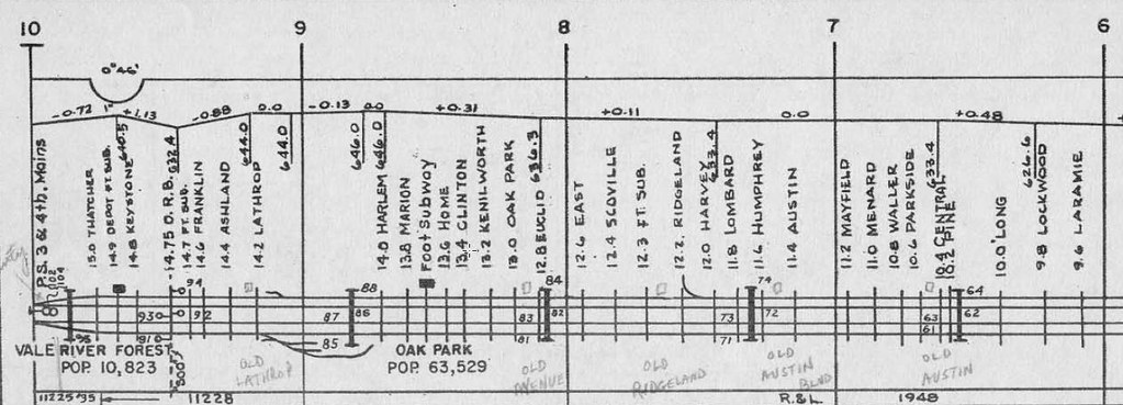
River Forest was Thatcher before 1882 and is still in service under Union Pacific since 1995.
The first station was a ground level under the Galena
& Chicago Union in 1848 which became the Chicago & North Western 1864.
Address is 8001 W. Central Street today.


So basically no answer or info. According to the Metra website the info on River Forest Station says it was opened in 1915. The UP West line tracks are elevated approx. 10 feet above street level beginning in River Forest and they stay elevated all the way to Cicero Ave. before the reach street level again. This station and the stairs that have been removed were clearly built into that elevation construction whenever that was done. I'm attaching Google Streetview photos of the removed stairs. Does anyone know when the CNW Westline was raised up above street level through that section? Based on the photo evidence my guess is that this may have been the original River Forest station before it was moved west to the current Thatcher location. Any insight would be appreciated.

Norbert
removed stairs to North Side CNW platform Ashland and Central..jpg
removed stairs to North Side CNW platform Ashland and Central..jpg (380.34 KiB) Viewed 6510 times
 #1431565  by qboy
 
I'm Engineer I work the UP West-line. While I'm no expert talking with some fellow old head Conductors and Engineers over the last 17yrs. Years ago there were stations stops Between River Forest headed east back towards the City. If you were to pay close attention you can make several footprints of former station stops. Your picture is an old former stop I believe called Lathrop since that's the name of the street and also lived on that street for yrs. Right at Oak Pk Ave you can see another footprint of stairs and what used to be very short platform. Some of these former stops line up with the CTA-L stops almost. Austin Ave on the north side you can make out what use to be an entry point for a station. Also before the CTA took over the ROW it currently runs on there used to be 4 main tracks. Between about what is today Kilbourne Ave to CP Vale which is just west of River Forest. The way it was explained to me the outer tracks were for locals which is why you see the footprints of the numerous short stations. The middle 2 tracks handle the intercity long distance trains along with freight trains. Oak Park(Marion St) with the long south platform which can handle easily 10 cars was for long distance trains as was explained to me. I've seen couple of pics maybe on flicker or some where of River Forest with the old south platform and 4 tracks going through it. This pic had to be from the 70's but it was almost like short 4th track that went east of the depot, but appeared not be getting much use. Like I said this info comes to me from current and former CNW TE&Y guys. I'm sure some else may have more or better info than me. I'm not certain of the exact yrs of these stop and fourth trk I'm gonna guess before the 1950s.
 #1431569  by qboy
 
The other part of your question dealing with the elevation of the Geneva Sub. Has to do with the City of Chicago passing a law some time in the early 1910-1920s have all most train lines built above street level. Like UP West-line, UP Northwest-line, UP North-line, and similar the BN, Rock Island lines for the most part all run above the street level through most of the city. On my line the UPW Kilbourn is the only road crossing we have in the city of Chicago. That street came along years after the line was originally elevated.
 #1431572  by Allouette
 
I grew up in River Forest in the 1960s. The intermediate stations east of River Forest were closed in the 1950s sometime before construction began to relocate the Lake Street L up on the C&NW embankment, a task completed in 1962 - I don't have the closing date handy but I think I can find it somewhere. The River Forest station building itself was closed about the same time but was used by MofW workers during the 1960s. C&NW stored crossing gate blades in the tunnel under the tracks. The platforms remained in use but only a few trains a day stopped there. The old Oak Park station was an open agency station with a ticket agent until at least 1971. The intermediate stations were at about half-mile intervals. The Lathrop steps, like many of the other intermediates, had pipe handrails and were only blocked off by a plywood barricade near the bottom.

The Geneva sub was five tracks to at least Oak Park from the time of elevation (1909?) until one of the tracks was removed around 1930 to allow a water line to be constructed to supply steam locomotives at Proviso Yard. The line was reduced to three tracks at the same time the intermediate stations were closed to make room for the Lake Street L.

First and Fastest ( http://www.shore-line.org )has had a number of articles on the C&NW Geneva sub in recent years, including some fantastic historic photos by A.W. Johnson.
 #1431621  by Allouette
 
After some digging I found the Winter 2008 issue of First & Fastest, which has several pages of A.W. Johnson photos taken between Central Ave in Chicago and a bit west of Harlem in River Forest between 1927 and 1933. According to the article, the line was elevated in 1912 through Chicago and Oak Park, and 1915 through River Forest. The line was originally six tracks, cut to five when the water pipe to Proviso was added, probably after 1933. The closing date for the intermediate stations was December 1958 - after I was born but before I moved to River Forest. Stations closed from west to east were Lathrop (River Forest), Avenue (Oak Park Avenue, Oak Park), Ridgeland (Ridgeland Ave, Oak Park), Boulevard (Austin Blvd., Oak Park/Chicago) and Austin (Central Ave, Chicago). The Austin station was named after the Austin section of Cicero, annexed to Chicago in 1899. Oak Park was a stop for all C&NW intercity trains including the City streamliners.

The path of the water pipe, built to bring Chicago city water to Proviso, is still obvious on the embankment, being the location of the outbound platforms at Oak Park and River Forest.
 #1432027  by eolesen
 
Here's a track diagram from 1959. You can see the former stations penciled in. Too wide to include here, but you can click thru to it.

https://c1.staticflickr.com/5/4159/3462 ... cd9d_b.jpg" onclick="window.open(this.href);return false;
 #1432046  by Allouette
 
eolesen wrote:Here's a track diagram from 1959. You can see the former stations penciled in. Too wide to include here, but you can click thru to it.

https://c1.staticflickr.com/5/4159/3462 ... cd9d_b.jpg" onclick="window.open(this.href);return false;
The numbers on the top of the diagram are C&NW mileposts. The thin lines across the tracks are passages or bridges under the tracks, except for the Soo Line bridge over the C&NW at 14.75. The depot PT subway is the tunnel to the outbound platform, closed and used for storage in the 1960s but open now. There is a stairway from the platform down to Thatcher that the commuters on the few weekday-only trains that stopped there in the 1960s used. The P.T. Subway at 14.7 (Park Avenue) is a pedestrian tunnel because the dip for the Soo Line bridge made the track level too low for a street bridge. All of the bridges were and are low, the ones at Keystone and Thatcher flooding regularly after heavy rains. The thicker lines are signal bridges, equipped with horizontal three-light signals in the 1960s.

The whole area south of the C&NW and east of the WC/Soo Line/CN is rich in railroad history, including a bewildering array of connections, leases, sales, financial shenanigans and shady operators. The railroads involved include C&NW, St Charles Air Line, IC, CB&Q, Northern Pacific, the Lake Street Elevated, the Chicago and Great Western (NOT the later CGW). As one example the arcs of Brown and Circle Avenues in Forest park trace two legs of the wye connecting the Galena and Chicago Union to the St Charles and Mississippi, a predecessor of the StCAL. The curve of Park Drive in River Forest traces the steam-dummy Chicago, Harlem and Batavia, which got as far as the cemeteries just west of Des Plaines Ave. in Forest Park. The Suburban Railroad, the trolley line that later became part of the Chicago and West Towns, operated bits and pieces of several of these lines, including electrifying about a mile of the Wisconsin Central.