by diburning
I ride the red line almost every day to get to class. I encounter one every week or so. Maybe theres no sticky substance because the maps were peeled slowly?
Railroad Forums
Moderators: sery2831, CRail
mattl wrote:So here's one for you... any maps in the system still showing the E line intact? Plenty of Orange Line maps showing the Arborway stop, but I've yet to see a Green Line map without that white part after Heath St.Correct me if I'm wrong, but I believe these maps exist at Harvard Station on the Red Line platforms. Specifically, the maps located on the wall across the tracks from the platform show the E line terminating at Arborway. Perhaps these are still there because their location makes them difficult to access.
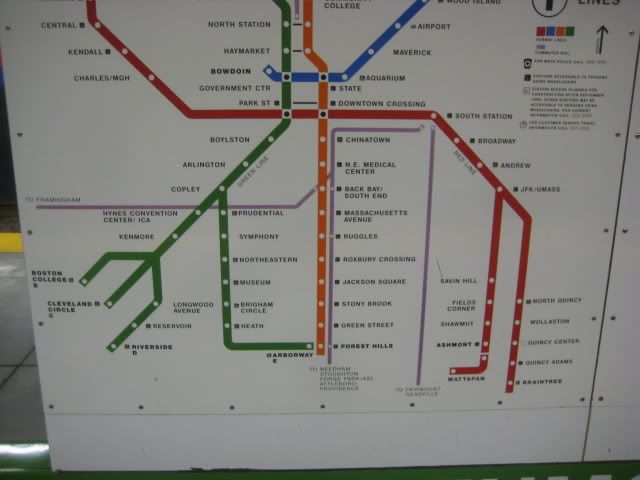
mattl wrote:So here's one for you... any maps in the system still showing the E line intact? Plenty of Orange Line maps showing the Arborway stop, but I've yet to see a Green Line map without that white part after Heath St.Yes, but only in full system spider maps that showed just subway stops and terminals on the branches. There are no maps beyond the white-outline GL branch maps that show every stop on the line. Spider maps from '67 to the mid-80's never showed every single individual surface stop on the A/B/C/E branches, only the D in certain cases. Only the handful of most important stops were cited, as well as any places where a train would conceivably be short-turned. Green Line stations did not have separate branch spider maps as detailed as the ones they do now, naming every single stop on every single branch. It was also a relative rarity for surface stops to have any maps or much in the way of signage on the platform. If the platforms had any markers, it was a tiny pole-attached sign or a generic bus-style sign mounted on top of one of the old aluminum shelters (like Hawes and Kent St. had before they got their new glass shelters). Street-running stops had nothing whatsoever. It still was very much seen as a streetcar line when the A and E were either operating or in "We'll be back real soon! (*wink-wink*)" status, with surface stops in a second tier between the subway and buses. You looked on the train or at a paper map for your stop, like a bus. It was only in the last 20 years when ADA compliance started to become a consideration and they had their first long-range inklings of doing across-the-board electronic prepayment that surface stops started to gain equivalency on signage to subway stops.
F-line to Dudley via Park wrote:BU West might've been one of the last since it's still an un-renovated stop, but I'm almost positive its maps were updated at BU's behest.I walked by BU West last night, and despite having been renovated with new shelters within the past year, to my surprise it actually still has the Green Line maps with the "suspended" Arborway branch in white but with all stops listed between Copley and Arborway (the same map that is still present at Hynes).
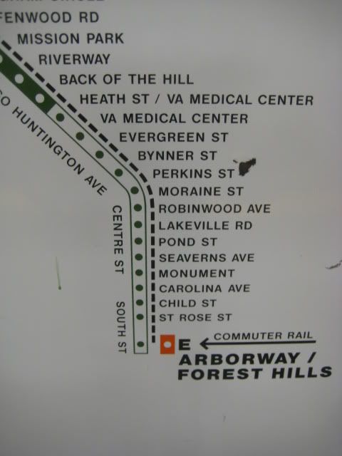
rhodiecub2 wrote:Was a similar style spider map of the GL that came before the restoration to Heath St? I think I remember seeing a GL map around early 1989 that showed the E branch going as far as Brigham Circle and Hynes Convention Ctr was still Auditorium.1986-89 the E only went as far as Brigham because they were relocating Forest Hills and replacing track on the entire street-running portion (that's right, entire...all of the non-restored route had its track replaced, but never the catenary to make it LRV-operational). Service to Heath Loop belatedly reopened in '89. So yes, that was a short-lived configuration. I'm surprised it made its way onto a single map, though.
rhodiecub2 wrote: Found this old green line map on the Winter Street Concourse last summer. Looks like a late 70s era map.Or early-80's. Wow...I didn't think there were any survivors left that still had "Auditorium" as the name for Hynes.