Railroad Forums 

  • Metro's 2040 Plans: New Blue, Yellow and VA lines

  • Discussion related to DC area passenger rail services from Northern Virginia to Baltimore, MD. Includes Light Rail and Baltimore Subway.
Discussion related to DC area passenger rail services from Northern Virginia to Baltimore, MD. Includes Light Rail and Baltimore Subway.

Moderators: mtuandrew, therock, Robert Paniagua

 #1220135  by JDC
 
Metro's PlanItMetro blog just released a lengthy post discussing Metro's research showing that, based on 2040 ridership projections, a separate Blue and Yellow line in the core will be needed to handle the crowding. What was new (at least to me) was the discussion of the need for another Virginia line into the core. See the post (http://planitmetro.com/2013/10/03/rtsp- ... eeting-10/).

A brief add-on: check out the last few pages of the TAG pdf (http://planitmetro.com/wp-content/uploa ... tation.pdf), which has a very interesting chart of the various proposals and how each Metro line would look, including intervals and end points.
 #1220339  by Sand Box John
 
"JDC"

A brief add-on: check out the last few pages of the TAG pdf (http://planitmetro.com/wp-content/uploa ... tation.pdf), which has a very interesting chart of the various proposals and how each Metro line would look, including intervals and end points.


The only thing I found interesting in those slides is the intervals. Reduction in headway from the presently advertized 3 minutes to 2 minutes. They could relieve the present overloading on the existing system by reducing the headway from 3 minutes to 2 minutes by simply procuring more rolling stock and building the infrastructure to support it.

The figures in slide 53 seem to me to by pretty high. The land use trends over the last 25 years has been towards building commercial square footage outside the urban core. I happen to believe the urban core commercial square footage will peak at a level below the figures predicted in slide 53.

Slides 23 and 24 show what I have been predicting for at least 4 years. A significant number of boarding generated by the Silver line west of Tysons Corner will not be heading to destination east of the Arlington County line.
 #1220383  by JDC
 
John - I concur on both the questionable use of overly optimistic land use projections and that the Silver Line will generate boardings headed toward Tysons in a sizable amount.

Question to John, and everyone - what do you make of:

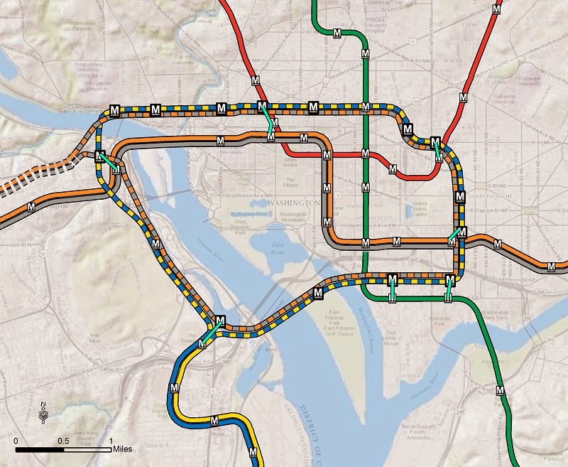
1) scenario A and B and the creation of "loops" through the core? From a purely station location perspective, A seems to be doubling down on established areas (which have overcrowding admittedly) and neglecting up and coming areas and non-served areas. This, in my mind, would be a huge loss of potential because if a new downtime line is ever built, it would be decades before another line is built. Thus under served/non-served areas would continue in that status. Further, I think the loss of direct Yellow service at L'Enfant (though they're providing a walkway) would hurt the VA-MD connection by adding further steps between the two and, moreover, the loss of the Yellow line northwards to at least Mt. Vernon seems unwise. Lastly, what would prompt a station at East Potomac Golf Course? If that entire "island" were redeveloped into housing and commercial space, then I can see a need for a station. But otherwise I would have to think it would be completely underused.

2) scenarios A and B actually preempted a post I was contemplating. I had been thinking about the merits of a new underground line in DC that would be completely located within the core, totally separate from the other lines but connected at key terminals with walkways, and designed as a loop. This would be a truly "subway" line, with smaller headways, maybe 24 hour service, and less grandiose stations. It would look like scenario B, but pushed further east and not crossing into VA. This type of line would "throw a bone" to the concept that DC is a city, and needs a city-style subway rather than commuter-style transit. It would also, I imagine, increase the connectivity of the core and lessen the demands on the system (i.e. the commuter transit part) for intra-core trips.

3) scenario C. Boy where do I start with this one. Per the post, this option provided the best means of getting people into/out of the core. I see this logic, since it separates Blue/Yellow and thus creates more room on Silver/Orange and Green, and also creates a whole new Orange/Silver express line. It's the express line that raises a whole host of questions and I did not see any answers in the post of pdf. For instance, from where to where is the line express? Does it run express from Rosslyn to Tysons? McLean? Wiehle? A big problem I see is that it then joins up with the new B/Y lines, so we would again have 4 lines sharing a track downtown and any emergency singletracking would back up not just the regular B/Y lines, but also the express lines into the core, absent a third track or very good pocket track locations. In the end, it's almost silly to think too much about scenario C, since I cannot imagine it ever being built due to the cost of an express line from Rosslyn to the Tysons area, all of which would need to be underground I imagine. I think the best "express" proposal is John's proposal for a Tysons bypass that would shorten the trip to/from Dulles. John - can that bypass still be built once the Silver line is up and running as planned?

4) scenario D. I like the new M street Blue line, but it seems odd to have it end at Union station without going further east/north east into under served areas. I like the Yellow line to Thomas Circle for purely personal reasons, but wonder again whether it makes sense to end the line at that point and leave areas to the north under served. The best thing about D are the streetcar/light rail options, but none of that is really Metro.

Lastly, is the Red line really in need of no further work as envisioned by this project? And by that I mean is there no large capital project that would make sense for the Red line by 2040? The crowding data provided in the post shows that 8-car trains take care of the Red line for decades to come. I suppose there just is not as much growth on the Red line as is projected in VA.....
 #1220734  by TheOneKEA
 
These are interesting plans but I like Sand Box John's proposals much better. The M Street Blue Line through to D&G Junction with the four-platform terminal/through station at the Anacostia River, combined with the round-the-corner connections at L'Enfant, Pentagon, Rosslyn and Farragut, looks just as good to me as these plans. I would like to see Sand Box John's plan evaluated by the same people who evaluated these plans.
 #1221008  by Sand Box John
 
"TheOneKEA"
These are interesting plans but I like Sand Box John's proposals much better. The M Street Blue Line through to D&G Junction with the four-platform terminal/through station at the Anacostia River, combined with the round-the-corner connections at L'Enfant, Pentagon, Rosslyn and Farragut, looks just as good to me as these plans. I would like to see Sand Box John's plan evaluated by the same people who evaluated these plans.


That track schematic is based on one of WMATA's early proposals for the M Street subway. Future Metrorail Capacity Needs Planning, Development and Real Estate Committee Board Information Item VIII-A April 24, 2008 (423 KB PDF file) page 15. The four-platform station in D&G Junction is a creation of mine to maintain the balance of capacity at both of the convergent divergent points of the Blue and Orange lines. The map on page 15 does not show how the connection of the M Street subway would be laid out at D&G Junction. The schematic was originally drawn in response to Tweaked Rosslyn station on Metro 2030 map at Greater Greater Washington. David Alpert even published a separate post on the original schematic, 2030 track map. The updated version of the 2030 schematic can be viewed here.
 #1231548  by JDC
 
A DC blog had a post recently with a nice graphic showing potential routing for a separate Blue Line. http://dc.urbanturf.com/articles/blog/m ... etown/7870. I recognize this is completely unofficial and likely not based on any practical considerations, but I do like some of the route, though I find the station naming somewhat weird (such as repeating NOMA for both Red and new Blue).
 #1231704  by afiggatt
 
JDC wrote:A DC blog had a post recently with a nice graphic showing potential routing for a separate Blue Line. http://dc.urbanturf.com/articles/blog/m ... etown/7870. I recognize this is completely unofficial and likely not based on any practical considerations, but I do like some of the route, though I find the station naming somewhat weird (such as repeating NOMA for both Red and new Blue).
The Blue Line re-route graphic shown in the urban Turf blog is from one of the earlier TAG presentations, so it is not completely unofficial. It was a route and set of stations that were analyzed for ridership. The NoMA station name used in this graphic predates the name change for the New York Ave station.

With the ANCs getting on-board in support of a re-routed Blue Line, WMATA is making progress in the long process of building a public consensus for the Blue Line route concept. The route from Georgetown along M St and to Union Station is the established part; where the line would go east of Union Station is an open question. I question whether it would be practical to build 2 stations in Georgetown as they would not be very far apart. Also each station will be expensive, could see Georgetown consolidated to 1 station with entrances at either end to trim costs.
 #1231767  by JDC
 
I concur on one station for Georgetown. What I wonder is whether it could be situated in such a way as to have several entrances at key locations, one of them possibly being close to GWU (though not as close as a separate stop), but using moving walkways as one way to getting passengers from somewhat far-flung entrances to the platforms. They use it in airports after all.
 #1231779  by Sand Box John
 
One must think three dimensionally when considering the location of a station in Georgetown, more so if there is an intention to put one near Georgetown University. Any station near Key Bridge under M street would need to at least as deep and possibly deeper then the Rosslyn station to get under the river. The reason why is two fold, one; a station near Key Bridge would have to be deeper to tunnel through the bedrock under the river and two; the tunnels would have to be deeper to tunnel under the K route Orange line tunnels to reach Arlington Cemetery.

A station in the range of 100' to 130' deep using escalators would allow the surface entrances to be as much a 1,400' apart. Dupont Circle is an example of that. A station any deeper would likely be accessed exclusively with elevators placing those entrances closer to each other.

If WMATA chooses to build a tunnel under the river above the bedrock then things change big time.

I think a Georgetown station should be located roughly halfway between Key Bridge and Wisconsin Avenue with escalator entrances at Wisconsin Avenue to the east and near Key Bridge to the west.
 #1231869  by JDC
 
John - how do tunnels built on bedrock work? Do you have an example somewhere else to look at?

Also, is a bridge an absolute non-starter? I know there are aesthetic issues, but technically speaking for a moment, if the new Rosslyn station was situated at the correct depth (likely higher than the current station), could the tunnel then proceed north(ish) from Rosslyn II, emerge from underground near Lee Hwy and N. Lynn St, parallel the Key Bridge on a new bridge, and then bank sharply to the right to meet the Georgetown station somewhere near where you proposed?

I guess a key part of this routing would be where exactly is the new Rosslyn station - the further to the west it is, the more room there would be for the tunnel to gently begin a curve into Georgetown. Has there ever been a discussion of where in Rosslyn to locate a second station? The generic presentations always show it further to the west.

As for the bridge and aesthetics, and personally find bridges interesting and attractive to the eye, when done right. The Yellow line bridge would not be a model for what I would propose here.
 #1231917  by Sand Box John
 
"JDC"
John - how do tunnels built on bedrock work? Do you have an example somewhere else to look at?


Building the tunnels above the bedrock would depend on where the top of the bedrock is in relationship to the river bottom. That is something I do not know. If the sediment between the bedrock and the river bottom is deep enough a pressure balanced boring machine can be used, however that boring machine would also have to be capable of boring through the bedrock on either side of the river. The other option is sunken tubes if the sediment between the bedrock and the river bottom is not deep enough. FYI the tunnels under the Washington Chanel on the L route Yellow line are sunken tubes.

Also, is a bridge an absolute non-starter? I know there are aesthetic issues, but technically speaking for a moment, if the new Rosslyn station was situated at the correct depth (likely higher than the current station), could the tunnel then proceed north(ish) from Rosslyn II, emerge from underground near Lee Hwy and N. Lynn St, parallel the Key Bridge on a new bridge, and then bank sharply to the right to meet the Georgetown station somewhere near where you proposed?

I guess a key part of this routing would be where exactly is the new Rosslyn station - the further to the west it is, the more room there would be for the tunnel to gently begin a curve into Georgetown. Has there ever been a discussion of where in Rosslyn to locate a second station? The generic presentations always show it further to the west.

As for the bridge and aesthetics, and personally find bridges interesting and attractive to the eye, when done right. The Yellow line bridge would not be a model for what I would propose here.


Obviously the station would be to the west of the existing station for the reasons you explain and to avoid the need to pass under or over the existing tunnels north of the Rosslyn station. I would place it under Fort Myer Drive, elevators would descent from the existing fare collection mezzanine, the opening for the transfer passageway between the existing station and the new station would be where the elevator that was built when the station originally opened is. Plans call for the removal of that elevator to accommodate the development of the property adjacent to new elevators.

I happen to believe the second Rosslyn station should also be a split level station like the existing station to allow for a junction so all three lines would have access to the M Street subway. See my 2030 track schematic.
 #1234028  by JDC
 
Whew. Where do I begin? Where do any of us begin when looking at this? I highly recommend everyone read the comments on the Planitmetro blog first, which highlight two key issues: 1) express tracks in VA really do no good if they end up merging into a new choke point as well as a combined Yellow/Blue/Orange/Silver circle line, with all of the two track issues we currently have; 2) the complexity of signaling to customers where a train is going in this system.

What I like about this proposal is that it keeps the idea of a new M street (or somewhere nearby) line going east/west through Georgetown and hitting union station but it also discards the idea of a separate Yellow line paralleling the Green line nearby and instead locates it further east in an under served north/south corridor. I also really like the added connections to southwest and southeast, areas that have great potential for increasing development and density.

I also appreciate the effort to fix the current Rosslyn choke point, but the result is a spaghetti dinner of lines merging and diverging and going in all sorts of directions.

At a fundamental level, I've previously supported - and continue to support - the idea of a 'circle line' in DC. But, in my mind, such a line is solely a circle/loop without branches outside DC. Thus this loop is separate from any consideration of express tracks in VA or a new blue connection into DC. In my mind, a circle line would be a true 'subway' dedicated to moving people around IN DC (not in and out). It could be a line with different hours, service patterns, fares, etc. But it would be a subway and not subway/commuter rail like Metro is currently designed for. Having a loop/circle line such as this avoids many of the issues that are being raised with regards to the complexity of a circle that is also a hub and spoke at two different points.
 #1234054  by YOLO
 
The loops are going to confuse the hell out of all the tourists that pop in and it's going to cause a mess. And do we really need silver express tracks if they're going to merge in a new choke point? A circle line is definitely nice to have but there shouldn't be loops like this, IMO.

What would be nice is if the new blue line continues east (join back up at stadium armory or nearby location) like i've seen on maps posted here before. the "new" yellow line can go along I St SW/SE and continue on to union station.

It would also be interesting if the silver line separates out at east falls church, pass through the columbia pike corridor, and go up the yellow line bridge ... if the streetcar project wasn't happening, would it make sense?
 #1234140  by JDC
 
Yolo - I like your idea regarding a Silver Line that goes south past EFC into the heart of the under served area west of the Pentagon (I would not count on a streetcar project just yet) before turning towards DC and using a new N/S tunnel, like the one the map depicts (plus or minus loops). I've long dreamed of a "Gold Line", which would essentially serve the area you mentioned - heading west from the Pentagon and following Columbia Pike into Bailey's Crossroads and then to Annandale and Burke.