Just west of where Bull Pond Road meets 293, there's an access road on the south side (on West Point land) which appears to be built on the little bit of ROW that was graded: it is pointed at what appears to be a curving cut, now occupied by a stream, on the east approach to the tunnel. Collectively, they curve from SW at the Bull Pond Road junction to about NNE at the portal. It shows up nicely on high-resolution DEMs. I can't find any trace of a west portal.
Railroad Forums
Hudson Suspension Bridge & New England Railway
- Pertaining to all railroading subjects, past and present, in New York State.
Moderator: Otto Vondrak
If the east portal of the tunnel is indeed still in existence (however obscured), and is probably located on West Point property, one would think that somebody at West Point must know it's there. What would it take to look into it?
https://orthos.dhses.ny.gov/?Extent=-82 ... ightMenu=2
 Screenshot at 00-39-50.png (511.64 KiB) Viewed 1538 times

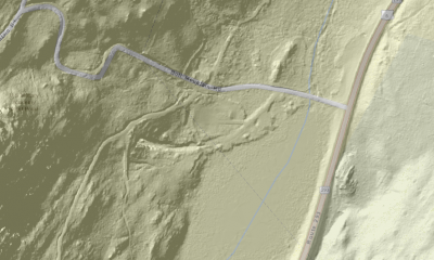
I'm afraid I need someone to interpret the GIS image for me. I'm trying to fit it to the description made by choess. I can discern the general area that we're talking about, but I need the possible tunnel location superimposed over the image or a topo map --- either that, or a more thorough description. Thanks.
trainsinmaine wrote: ↑Tue Aug 27, 2019 7:07 am I'm afraid I need someone to interpret the GIS image for me. I'm trying to fit it to the description made by choess. I can discern the general area that we're talking about, but I need the possible tunnel location superimposed over the image or a topo map --- either that, or a more thorough description. Thanks.Do you see the swoopy bit in the center, like a smile? And how it ends abruptly on the left? That's the tunnel portal.
RussNelson wrote: ↑Tue Aug 27, 2019 4:32 pmThanks. I assumed that, but wasn't certain. Soooo . . . . Assuming this thing does indeed exist (and it appears it does), the speculation is that the accessible portal is the west one. Choess's information states that there is no evidence of a west portal. Thus I'm confused. Also, is the entire structure part of West Point property?trainsinmaine wrote: ↑Tue Aug 27, 2019 7:07 am I'm afraid I need someone to interpret the GIS image for me. I'm trying to fit it to the description made by choess. I can discern the general area that we're talking about, but I need the possible tunnel location superimposed over the image or a topo map --- either that, or a more thorough description. Thanks.Do you see the swoopy bit in the center, like a smile? And how it ends abruptly on the left? That's the tunnel portal.
I used to work for the West Point utilities dept. (water and wastewater). The proposed tunnel location was on the Camp Buckner property. Not too far from route 293 was the start of a horizontal bore. It wasn't very wide or high. My guess was that the company started it to show investors that work was being done. I could crawl in a short distance. Somewhere I have a color slide of it. Going on the WP property these days would not be wise. Also in the same area was the Forest of Dean iron mine RR. The book "Vanishing Ironworks of the Ramapos" has information on it and old USGS maps show it. The sewage line outfall from Camp Buckner ran on the old roadbed and we used to walk it each spring to check for leaks. A bucket line took the iron ore to the docks at Fort Montgomery for the last couple miles because the grade was too steep for a RR. There was also the "Target railroad" near the golf course. It was about a foot gauge and remotely controlled electric power. It zig-zaged up a hill. The little cars carried targets which the troops had to shoot at. In the 1970s it was still intact but hadn't been used in years. I don't know if anything is left of it.
Thanks for that first-hand report, rhallock. I see West Point does have a hunting access program which could theoretically get someone into that part of the reservation (which I imagine explains how the existence of the tunnel was reported here: https://www.cs.dartmouth.edu/~sws/fun/runtales/sk.shtml), but it looks like a rather involved process, to say the least. The Forest of Dean mine railroad and associated aerial tram are discussed in the late Bill Myles' book on Harriman trails, I think.
There was to be a bridge built for carts & railroad from Storm King Mountain at Cornwall NY to Breakneck Mountain between Cold Spring & Beacon NY, to connect NY & NE RR on east side of Hudson river to what became the Erie RR on the west side; there are some segments of RR grading thru T/O Putnam valley in Putnam County that were of part of the iron mine rr's.
https://archive.org/details/bridgeacros ... w=theater
https://archive.org/details/bridgeacros ... w=theater