Railroad Forums 

  • Unfinished railroad from Richfield Springs to Ft. Plain

  • Pertaining to all railroading subjects, past and present, in New York State.
Pertaining to all railroading subjects, past and present, in New York State.

Moderator: Otto Vondrak

 #356372  by henry6
 
If it goes parallel to the river valley, it could be canal related, even channeling water into canal and river. If it "branches away" from or is perpendicular to the valley or the railroad, then it might even be an old lumber road or other road, even a farmer's right of way. Unless you dig into the history books and the charter files at the court house or in Albany, you'll just get dead end answers.

 #377397  by NaDspr
 
WShore4Ever -

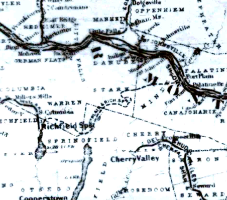
You wrote: Unfinished railroad from Richfield Springs to Ft. Plain
--------------------------------------------------------------------------------
"I am trying to locate information regarding the subject railroad. Having grown up in the Ft. Plain area, I clearly remember seeing remnants of the ROW (cuts, fills, bridge abutments, etc), but I have never found any pictures or significant published text on this line. I believe that construction started near the end of the 19th century or early 20th century? I have no evidence that it got to the rails-on-ties stage, much less engines or rolling stock."
---------------------------------------------------------------------------------
This line did end up under the control of the Southern NY Railway.
There was also a plan to build another railroad from Cooperstown to Ft. Plain under the name of Cooperstown Northern. There was some grading visible of this line too. It was to come north from Cooperstown on the west side of Otsego Lake. The ROW is very visible just east of the intersection of Rts 20 & 80 on the south side of Rt 20. The ROW north of Rt 20 has a car wash on it but a cut thru the hill behind the car wash is visible.
[/quote]

 #377557  by RussNelson
 
NaDspr wrote:There was also a plan to build another railroad from Cooperstown to Ft. Plain under the name of Cooperstown Northern. There was some grading visible of this line too. It was to come north from Cooperstown on the west side of Otsego Lake. The ROW is very visible just east of the intersection of Rts 20 & 80 on the south side of Rt 20. The ROW north of Rt 20 has a car wash on it but a cut thru the hill behind the car wash is visible.
Hmmmm..... The Richfield Springs and Ft. Plain railroad went through the intersection you descrie (Springfield Four Corners). See http://rutlandtrail.org/gmap.cgi?richfi ... n.ny.track
 #396263  by A Woodruff
 
Most of the work on this ill-fated line was done in 1894, with meetings, surveys, etc. being done beforehand. In several places, the gradings are still visible between Fort Plain and the Rte. 80/US 20 intersection. One newspaper article mentions workers storming into Van Hornesville with pitchforks and other weapons when the paymaster did not arrive on time.
Richfield Springs already had a railroad and fund raising efforts there were not too successful; I suspect that this is why I can find no remnants between there and the four corners.
A separate project around 1903 was listed in newspapers as "Rails to Springfield" (from Cooperstown.) The name Cooperstown Northern was then changed to Cooperstown and Mohawk Valley. Efforts to take land for it by eminent domain from a couple prominent Cooperstown individuals resulted in legal action, which voided its charter and stopped construction.
I have a copy of the FP&RS survey for Herkimer County and have seen similar ones for the sections in Montgomery and Otsego counties. The one I have is dated during the 1880s. I also have copies of a number of newspaper articles on these projects.
A Woodruff
 #405856  by A Woodruff
 
Hello, Wshore4ever.
I have tried to contact you previously regarding the Fort Plain and Richfield Springs Railroad. Are you still interested in it; if so, I have some literature you might like to see.
A Woodruff
 #408205  by lvrr325
 
A Woodruff wrote:Most of the work on this ill-fated line was done in 1894, with meetings, surveys, etc. being done beforehand. In several places, the gradings are still visible between Fort Plain and the Rte. 80/US 20 intersection.
Would this be the ROW-looking embankment visible going south of 20, just east of where it crosses 80, east of Richfield Springs? Always wondered what that was, but I assumed it wasn't RR related.

 #497942  by RussNelson
 
FYI, the railroad under discussion here is on the map linked from this page:
http://www.nysl.nysed.gov/scandoclinks/ocm08679887.htm
Click on the "View Document" link, then click on the bottom of the list of links. That will show you the Map link. Click on it to get a popup which will show you the PDF. It's a big PDF which is a scan of the Annual Report of the Board of Railroad Commissioners of the State of New York for 1895.

No, I have no idea why they make it so hard to access these documents. To make it easy for you, I've exerpted the section of the map here:
Image
Last edited by RussNelson on Wed Apr 16, 2008 10:55 am, edited 2 times in total.

 #498859  by WShore4Ever
 
Henry6,

I have corresponded with AWoodruff on this type off-line and we can confirm primary documentation that it existed - on paper and in profile, if not completed and in operation.

AWoodruff,

I haven't forgotten, still hope to arrange a discussion over coffee...

WS4Ever

 #525856  by RussNelson
 
Here's a photo of the bridge abutments and pier halfway between Hallsville and Starkville:
Image
According to the New York Times article linked from my Unfinished Railroads page, at least some of the undercutting of the stonework happened in 1903, at which time they were still trying to put the railroad through.
 #800321  by brakeman44
 
Hi Russ;

I am historian with the Leatherstocking Railway Historical Society, and I did an article on the Fort Plain and Richfield Springs
Railroad, and I documented asmuch of the line as I could locate. I took photos of the stone abutments just below Fort Plain and sections of the ROW wherever I could find it. There's a good sizwe piece just above Route 20 in the town of Springfield, and i followed it all the way along Stone Quarry Rd. However, I could not figure out its route thru Hallsville and Starkville and Van Hornesville. If you would like to get together sometime and compare notes I would like to find out more about this line. By the way, the entire line was graded and the ties were setting in Ft. Plain waiting to be put down before the Company went down for the last time. I would like to hear from you - my E-mail is [email protected]

Jim loudon
 #1632285  by RussNelson
 
Thanks to a map in Jim Loudon's book The Cooperstown and Northern subtitled Otsego's Forgotten Railroad (includes a chapter on the Fort Plain & Richfield Springs Railroad), I was able to locate some of the Cooperstown & Northern grading. Here: https://www.openstreetmap.org/way/1219429342

I expect there is more.
 #1632291  by RussNelson
 
brakeman44 wrote: Sun Apr 25, 2010 5:21 pmHowever, I could not figure out its route thru Hallsville and Starkville and Van Hornesville.
I have it partially correct in OpenStreetMap here: https://www.openstreetmap.org/way/172946242 but not through Springfield Four Corners, which is the C&N.

It's quite clear going east of Van Hornesville on the LIDAR (https://orthos.dhses.ny.gov/). South, I believe it follows NY-80. https://orthos.dhses.ny.gov/?Extent=-83 ... =hillshade

At Starkville it has to come down a big hill and so circles way out east and then back west before coming into Starkville. I think there was a trestle involved west of NY-80 there. Definitely a trestle east of Wagner Hill Road. Lots of erosion at Elwood Road.

Once past Starkville to Hallsville it goes through a lot of fields, but there are bits and pieces of the grade left, enough to let you know where it was.