Railroad Forums 

  • Sonwill industrial track near the WSRR

  • Pertaining to all railroading subjects, past and present, in New York State.
Pertaining to all railroading subjects, past and present, in New York State.

Moderator: Otto Vondrak

 #1538883  by SST
 
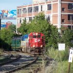
Its been a long time since we've discussed anything concerned with the Gardenville Line/Sonwil Industrial track. Their is still service on the line. The warehouse somewhat near the WSRR is still receiving boxcars. Their were two the week before last and another two again last week. Its the first time I've been through the area since early last year.

Two weeks ago, I was riding my bike to the Amtrak Depew station. Needing exercise desperately. As I approached George Urban Blvd, I ran over shards of glass before I saw them. Within 20 seconds my front tire was flat. 2 hour walk home. To cut some distance, I walked up the line towards the airport. I haven't actually walked a line in years. It felt good to explore again looking for things. Which brings me to this post:

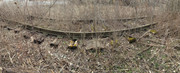
Lots of torn up rails and ties. But CSX must have done a clean up operation as the piles of rails and ties were gone. Dang! No pick'ins remaining. As I continued beyond the warehouse still receiving boxcars, I couldn't see some very long railroad ties under the active rail. I assumed this meant that a switch must have been there along with a spur into another warehouse. I started looking for the track bed where this spur would have been but the brush was thick and it looked like it was bulldozed flat long ago. I kept walking. But I also kept turning around...something kept telling me to turn around. And suddenly, I see something......I walk back 50 feet and to my amazement the spurs rails and ties are still perfectly intact. I've walked by here several times long ago but never saw this. But then I realized I'm usually here in the summer with leaves on the trees and bushes. And it is THICK!

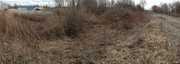
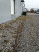
There are no rails from the where the switch would be and then across the access road. It basically starts where the bushes start and goes all the way to the warehouse which is mostly buried in stone. Here are some pictures:

Image

Image

Image
 #1538906  by SST
 
This is where the WSRR and the Gardenville Line began. Across the street from the Buffalo Airport. Genesee St @ Sonwil Drive Cheektowaga. This is the first warehouse on the street.
 #1538973  by Fireman43
 
interesting pics - one of those. WHO KNEW?

I've always wondered in this area the ROW of the LV. as it heads north from Walden up and over Genesee. Did the LV ROW. parallel closely the Gardenville line or was it further east most of the way through what is now the golf course ? I can remember the LV bridge over the WS and Genesee St, only thing left now are the abutments on the south side . I know it's been, what 40 years ? since the line was taken out but the ROW conpletely undistinguishable through this area.

LV ROW at Genesee Street
https://www.google.com/maps/@42.9352551 ... 384!8i8192

LV ROW north bound at Walden under the CSX Mainline
https://www.google.com/maps/@42.9102906 ... !1e3?hl=en

Mark
 #1538980  by TrainDetainer
 
Ben - He's talking about the large food warehouse just north (3rd building) of the Sonwil building.

Mark -
LV was about 2500' east of the Gardenville/Mainline underpass and about 1800' east of where the Gardenville started to curve east toward A.
WN.png
WN.png (1.14 MiB) Viewed 1895 times
 #1539028  by Fireman43
 
good map indeed - didn't think thru my question as completely overlooked that ROW to the east which would have 'connected the dots'. Which now I click as to when Id drive down French Road I'd always look and think that depression behind their houses must be the LV ROW.

https://www.google.com/maps/@42.9187669 ... !1e3?hl=en

So many questions so I won't jump around - too much - but............... I always liked to think the WSRR. 'began' at Harlem Rd and Walden when it used to go under Harlem as it headed east before the whole area was transformed with development and the Walden Galleria Mall taking over the ROW.

https://www.google.com/maps/@42.9066541 ... !1e3?hl=en

Simplistic thinking?

thanks again for clarifying with your map.

Mark
 #1539029  by Fireman43
 
Hit send too quick - I do have a question on mapping.
I went to ACME mapping to follow your map and see the ID. on the different lines. Always thought this was essentially a historical map but I see the mainline is labeled Conrail so updated not to long ago but I know now CSX?
Is there another mapping site anyone would recommend I could use to look around?
Mark
 #1539031  by TrainDetainer
 
I forgot this last night - here's the 1927 county aerial view of A and the LV. Genesee and Transit were country roads, and no golf course. That's not the airport under the J24 label, it's still small and all west of S Young's Road at that point.
NYWSB A 1927.png
NYWSB A 1927.png (633.32 KiB) Viewed 1806 times
 #1539034  by NYCRRson
 
"I always liked to think the WSRR. 'began' at Harlem Rd and Walden when it used to go under Harlem as it headed east "

The New York, West Shore and Buffalo Railway actually started at their passenger station which was close to Downtown Buffalo. The ROW ran right in front of BCT basically on what is now Memorial Drive (used to be Lindbergh Drive named after some old airplane driver). Then it ran to the WSRR Engine terminal which was later known as the Bailey Ave roundhouse. This was about the Northwest corner of what later became the Frontier Yard. The northern half of Frontier yard was on the location of the old WSRR freight yard. Then the tracks headed under Harlem, through the Galleria Mall property and east crossing Transit Road under an overpass for Transit road vehicle traffic. Some time in the 70's they tore out that under pass and leveled the approach ramps and installed the "at grade" crossing we see today.

By the time they built BCT (and a lot of connecting tracks around it) the NYC no longer used the WSRR passenger station so they ripped up the westernmost part of the WSRR. The WSRR running East/West crossed the "Belt Line" running North/South approximately at Tower "T" which is just North of BCT.

I believe, but could be mistaken, that the Gardenville line (also known as the compromise track) was part of the NY & HR RR before the WS&BRR was purchased by the NY & HR RR.

Cheers, Kevin.
 #1539053  by TrainDetainer
 
Mark - one of the best map references for Buffalo is the Buffalo research page (a few map links are dead): http://www.buffaloresearch.com/maps.html. Erie County historical maps page has the 1927 aerials: https://www2.erie.gov/aerial_photos/ind ... otos-1920s. There are also the Sanborn insurance maps at LOC : https://www.loc.gov/collections/sanborn ... list&c=150.
Here's a couple more of mine of the Frontier/Memorial Drive area. Connections to the Belt Line are in place and West Shore torn up west of the split (shown separately only for reference) and Central Terminal/Memorial Drive are under construction. REA facility is already there.
EBuffalo 1927.png
EBuffalo 1927.png (1.05 MiB) Viewed 1753 times
Attachments:
BCT abuilding 1927.png
BCT abuilding 1927.png (924.37 KiB) Viewed 1753 times
 #1539075  by NYCRRson
 
TrainDetainer, nice maps, excellent job outlining the different ROW's.

I believe over time that after the NYC bought the WSRR they eventually used the "NYC Roundhouse" for passenger power (closer to BCT) and the "WSRR" round house (aka the "Bailey Ave. Roundhouse") for freight power (closer to the freight yards).

At one time (circa late 1950's early 1960's) the NYCRR built a "Diesel Shop" inside the WYE in the Belt line just North of Broadway. Apparently they where going to consolidate all engine servicing there. That was somewhat centrally located between BCT and the freight yards. Then the passenger train demand "fell off a cliff" and they never put that engine house into service. It was later demolished.

Instead they built new engine servicing facilities at the West end of Frontier Yard and scrapped both of the NYC roundhouses in the Buffalo area. (the one on the mainline and the Bailey Ave one).

My Father (NYCRR Fireman/Engineer circa 1941-1989) said he watched while stopped for a signal as the Bailey Ave shop forces took all the steam engine servicing tools (flue cleaning brushes, flue cutters, flue rollers, etc) out of the Bailey Ave. Roundhouse and tossed them into the turntable pit. Then they bulldozed the brick roundhouse into the pit to fill it in. I think there is a Tops store right around that location today.

Dang, there sure was a lot of railroad tracks stuffed into Buffalo NY.

Cheers, Kevin.
 #1539154  by TrainDetainer
 
Kevin -

I traced the old WS facilities and inserted the current GIS photos over the 1927 view to give a better idea of what fell on what. Tops occupies the site of Pullman's newer large shop building and transfer table. Most of the other buildings east of the 'new' shop location that are there now appear to be original repurposed Pullman/Wagner buildings (or at least locations) except for two - the Softball Central building is new but on an original location and the building due east of it is all new. The track currently known as 'the Pullman' at Bailey passes over the north side of the turntable pit.
WShore fac Bailey Ave.png
WShore fac Bailey Ave.png (1.19 MiB) Viewed 1631 times
 #1539165  by NYCRRson
 
TrainDetainer, excellent job with those old photo's and maps.

I think the old Pullman Roundhouse is still there but repurposed.

And the NYCRR had another complete engine servicing facility with a roundhouse over at Gardenville yard off Losson Road (near the current Stigelmeir Park);

http://nyc.railfan.net/buffalo/aerial/a ... ille51.gif

So my Dad often got called to pickup engines for service on a train (mostly freight but also passenger) at the "Mainline NYCRR Roundhouse", the "Bailey Ave Roundhouse", the "Gardenville Roundhouse", Kenmore Yard, and for switching out of the North Tonawanda yard (which had steam engines assigned to the that location, but no "roundhouse". And he worked out of the Niagara Falls yard (I don't know if there was a roundhouse there).

Back in "The Day" you couldn't drive a couple of miles without crossing over/under/above an active railroad track in the WNY area.

Dad was stopped with his train on the NYCRR Mainline (westbound I think) under the Bailey Ave Bridge when the bridge collapsed (from rust caused by all the road salt) onto his train and blocked his train and all the mainline tracks. I'm thinking that was maybe "78 or "79 ? Not too many Railroader's can claim their train was delayed because a road bridge fell on it....

Cheers, Kevin.
 #1539173  by BR&P
 
NYCRRson wrote: Thu Apr 09, 2020 8:14 pm

Dad was stopped with his train on the NYCRR Mainline (westbound I think) under the Bailey Ave Bridge when the bridge collapsed (from rust caused by all the road salt) onto his train and blocked his train and all the mainline tracks. I'm thinking that was maybe "78 or "79 ? Not too many Railroader's can claim their train was delayed because a road bridge fell on it....

Cheers, Kevin.
I had not heard that one, and a quick search didn't find it. Any more details? Unusual for sure!