Railroad Forums 

  • Seneca Army Depot-Anything RR left to view?

  • Pertaining to all railroading subjects, past and present, in New York State.
Pertaining to all railroading subjects, past and present, in New York State.

Moderator: Otto Vondrak

 #1520266  by SST
 
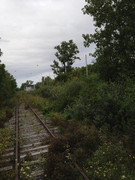
Well I took the tour. Kinda disappointed but the tour was mostly weaved around the Igloos [storage bunkers}. I took pictures of pictures that were better than what was left. So many people got so excited when any deer, especially the white deer came into view. I just kinda sat there waiting to move along. But then, it clearly shows that I am almost always against the grain of society which supports no social media. It probably would have been more fun if the sun was out and blue skies. Most of the rails that I saw were buried in brush. Still looked in okay condition

After the tour I drove into Geneva and saw the rail yard there. I've never been there before and was surprised at how many rail cars were there. I did see two Finger Lake locomotives there......1701 and 1703. A better ending to the day. I ate dinner at Pinky's.

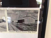
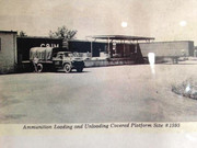
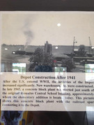
. Here are a couple of pics:

Image

Image

Image

Image
 #1520314  by TB Diamond
 
Very similar to our experience during the tour in 2006. Small yellow school bus, very crowded with the typical small windows.

Appears via satellite view that the Q Area may have had a rail spur. This ties in with some papers in my files that show a 10 ATMX car special train shipment with G-23 and G-24 scheduled to depart Kendaia Seneca Army Depot at 4:00 P.M. October 24, 1974 as Extra 324.
 #1520329  by BR&P
 
TB Diamond wrote: Mon Sep 16, 2019 9:54 pm Appears via satellite view that the Q Area may have had a rail spur.
Most definitely.

The general layout of track in that base, most recently, was a giant "U" with the open end and Area Q both at the north. Both ends of that "U" extended through the rows of fencing into the ultra-secure area. And I also had a conversation with an employee of a track contracting service who had performed repair in that area, under armed guard.

The satellite view I looked at some time back showed the east leg curved to the west at its end and ended near some buildings. This prompted me to wonder whether at its heyday that might have been a closed loop, connecting to the west leg and allowing for continuous movement.

I would love to see a track chart of the place in about 1950.
 #1521263  by Fireman43
 
In regards to development at the base I remember a year or so a company proposed to handle waste from downstate either by landfill or an incinerator and would bring in by rail to the property.
Needless to say things hit the fan with local opposition and if I remember correctly I believe Romulus ( or the county ) passed a local law prohibiting development of a landfill and/or accepting waste from downstate.

Also, I had wondered if rail access to the base would ever have had a connection to the passenger main on the east side but Ive answered my own question after looking at aerials and realizing the passenger main was gone what, only after about 20 years the base had been built so I suppose all rail shipments would have been via the freight bypass.

Used to camp a Sampson State Park in the 80's and can remember riding our bicycles following it seemed to be endless paved areas thru an area NE between the park entrance circle and the museum ( didn't this used to be the campground admin building?).

https://www.google.com/maps/@42.7302142 ... !1e3?hl=en
\

Looking on overheads now 35 years later I don't see any evidence of these paved areas- all overgrown now but I see tho the park advertises 36 miles of paved trails so Mother Nature has probably reclaimed many now into grass covered.

just a few musings........
Mark
 #1521275  by CarterB
 
If you use mapper.acme.com and coordinates N 42.77755 W 76.86170 in the topo view, you will see the entire rail network. North end was a closed "U" Area Q easily seen with bunkers in the satellite view. Lehigh Valley connections to the East, and West.
 #1521284  by BR&P
 
CarterB wrote: Mon Sep 30, 2019 4:57 am If you use mapper.acme.com and coordinates N 42.77755 W 76.86170 in the topo view, you will see the entire rail network. North end was a closed "U" Area Q easily seen with bunkers in the satellite view. Lehigh Valley connections to the East, and West.
No, I'll respectfully disagree. Now before I make my case, let me provide some descriptions which may help.

I don't know what the military names for the tracks were. And when FGLK assumed operations there, nobody bothered to create an official track chart providing names for the tracks. There was not even a map of the place. Train crews made their own names for the most part, and reported to the office where cars were spotted. Since different crews gave different names, in time at least one track was given 3 different names simultaneously.

For this discussion, the left hand vertical part of the "U" is the West Main, and the east part is the East Main. The bottom of the U where the yard is was the South Main. There are 2 places north of that where the two mains are connected - scrolling south on that Acme Mapper, or using Satellite view on Google Maps, will show these. Known as the North Loop and the South Loop for FGLK purposes, both those were outside the Q area. Find East-West Baseline Road, and scroll north 5 roads, you'll find Perimeter Road. Beyond that is the Q area. Following that East Main north into Q area, there are 4 cross roads, then a longer stretch, then you will see the track bend westward and stop as a small group of buildings.

Now find the West Main - the left hand of the "U". That goes north 3 roads past East-West Baseline Road, but stops before Perimeter Road, and before entering the secure area. There IS (was) a fence and gate across the West Main just past E-W Baseline Road but that's short of Q area.

One last thing - if you go on Google Maps at https://www.google.com/maps/place/Kenda ... 76.8869037 , there appears to have been a track or tracks, now gone, curving east from the west side of the base. That's inside the secure area. *IF* the West Main at one time did extend north into Q, this may (or may nor) have been another connection between the 2 sides.
 #1521287  by CarterB
 
Check coordinates N 42.77755 W 76.86170 again please, that seems to me to be at the North end of the site, quite a bit North of your Google maps site. Unless I am mistaken, tracks shown in N 42.77755 W 76.86170 are in Area Q
 #1521296  by BR&P
 
Carter, I think we're discussing two separate questions. You speculated the Q area may have had a rail spur. Go back about 5 posts, and I said "Absolutely" - I know the "East Main" did, and does, enter that area for sure.

What I'm speculating on is whether or not, within the Q area, at one time there was a connection all the way from the East Main to the West Main. At present there no longer is. And at present the West Main does not go far enough north to enter that area. What we need is an historic map of back 60 years or so. (The Acme map shows the prison which was built relatively recently, so it's not accurate for what "used to be".)
 #1521297  by BR&P
 
Where did you figure the east connection to LV was? The Acme map shows a disconnected track by that coordinate, no sign of it in the photo map but suppose that may have been where it was.
 #1521298  by CarterB
 
East connection at N 42.77745 W 76.85211 Use the USA Topo view to see old rail layouts. (box icon upper right corner)
 #1521300  by BR&P
 
Wow! For some reason I can't get the topo maps, but clicking on Satellite gives a different pic from the Google Maps one. And this clearly shows not only the LV connection, but shows the path of a "loop" or connection which comes out right where I was looking at on the west side, a couple posts up. Great, thanks! :-D
 #1521301  by CarterB
 
when you open mapper.acme.com....there should be a small grey box upper right corner. click on it for types of maps views. To get USA topo you have to zoom out quite a bit first. open it then zoom back in.
 #1521305  by Fireman43
 
To all: Thanks for the advice on how to properly use acme USA topo to show details :

------To get USA topo you have to zoom out quite a bit first. open it then zoom back in."----

Interesting now to toggle back and forth between the layers.

Without this tool guess I jumped to quick to assume was never a connection to the East main.

Mark
 #1521306  by BR&P
 
Didn't know you had to zoom out first, that was my problem. But when that didn't work I went to satellite and that was even better.

It's hard enough to find pics and info from regular railroads from that far back. When you add in the secrecy of military operations, there's just not a whole lot out there. Fascinating to learn this much. I've got to wonder whether the facility had some sort of "ETT" for its crews - they must have. But likely it was kept secure and I doubt anybody sent one home! :wink:
 #1522394  by MP366
 
What ever happened to the two center cabs that were sent in to replace the GP8/10 that were on the base? My understanding(and I may be way off “base”) was that when the military left they were required to leave some semblance of locomotives behind for use by the future owners.