Railroad Forums 

  • New Jersey's obscure abandoned railroads

  • Pertaining to all railroading subjects, past and present, in New Jersey
Pertaining to all railroading subjects, past and present, in New Jersey

Moderator: David

 #1484270  by MaRoFu
 
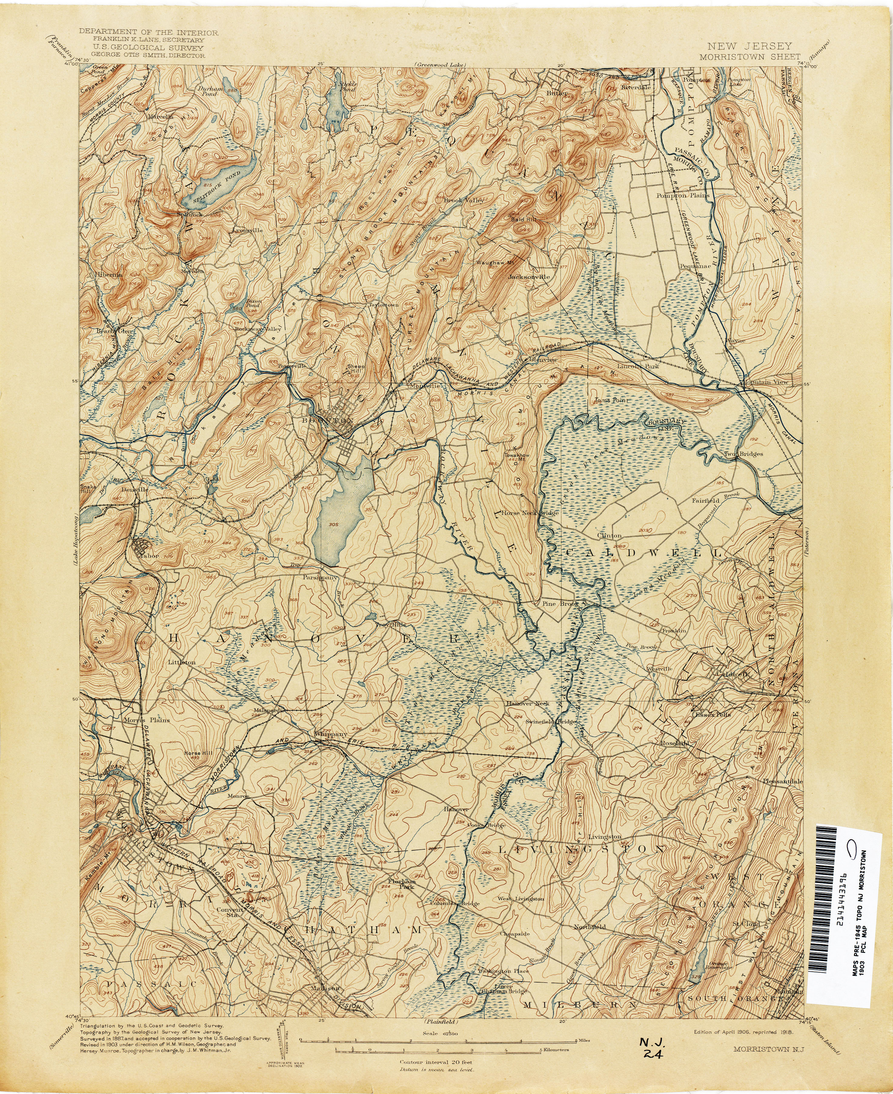
I've learned lately that NJ actually has many abandoned/defunct railroads that can only be found with hard research or by looking at rail maps. Some of you may have heard about the Hoboken waterfront railroad (forgot name), the New Jersey West Line (outside of Gladstone branch), and others, but there are a few ROWs I'm curious about.

- Mendham and Chester (diverges from M&E at Morristown and went to Mendham according to map)
- Unknown ROW branching off of NYS&W east of Newfoundland
- NYS&W switchback junction in same area?
- Former bridge over Hackensack River north of M&E bridge
- Possible Rail in Lincoln Park NJ? (When I checked an old map I noticed a straight line from the MB in Lincoln Park that indicated the existence of some sort of rail branch. Checked location on GE and a ROW exists)
Last edited by MaRoFu on Wed Aug 29, 2018 6:43 pm, edited 1 time in total.
 #1484272  by pumpers
 
MaRoFu wrote: - Former bridge over Hackensack River north of M&E bridge
This one we discussed here last fall. viewtopic.php?f=127&t=166159&p=1447603#p1446143" onclick="window.open(this.href);return false;
it was the first M&E bridge over the Hackensack from when they first built across the meadowlands, which tied into the Erie Long Dock tunnel through Bergen Hill. The Erie Newark & Hudson RR (later known as the Erie Newark Branch) then used it too (Erie running on the M&E!) Eventually the M&E build their own Bergen tunnel and built themselves a new bridge just south of the old one, at the location of the current one, to go to their own tunnel. The Erie took over the old bridge , which went away entirely by 1911 or so. The post has a link to a site with some good schematic maps.
JS
The Hoboken RR you mention was the Hoboken Shore RR . Wikipedia: https://en.wikipedia.org/wiki/Hoboken_Shore_Railroad" onclick="window.open(this.href);return false;
Now off to think about your other questions....
 #1484274  by pumpers
 
MaRoFu wrote: - Unknown ROW branching off of NYS&W east of Newfoundland
Green Pond Jct (NYS&W Jct with the CNJ (Wharton & Northern branch) coming up from the south past Picatinny Arsenal) is about 1-2 miles east of Newfoundland. Maybe that's what you are referring to. They interchanged there.
Here's a good site where you can view topo maps through the ages and see RR lines come and go: https://ngmdb.usgs.gov/topoview/viewer/#4/40.01/-100.06" onclick="window.open(this.href);return false;
Last edited by pumpers on Tue Aug 28, 2018 8:51 pm, edited 1 time in total.
 #1484285  by rr503
 
MaRoFu wrote: - Possible Rail in Lincoln Park NJ? (When I checked an old map I noticed a straight line from the MB in Lincoln Park that indicated the existence of some sort of rail branch. Checked location on GE and a ROW exists)
Do you mean the northbound ROW here? https://www.google.com/maps/place/Linco ... 74.3020933" onclick="window.open(this.href);return false;

If so, that's the old NYGL which once headed up to Pompton Jct with the NYSW and then to its eponymous destination. A small portion is still in use up around the NYSW IIRC. I'm sure you already know this, but it's important to keep in mind that the M-B is actually three distinct lines cobbled together: the DL&W Boonton Line (Denville-Lincoln Park) the Erie Greenwood Lake Branch (Lincoln Park-Montclair) and the DL&W Montclair Branch (Montclair-Branch Brook). A lot of the weirdness on/along the line is a result of that history.
 #1484346  by CarterB
 
If you check out the 1868 and 1872 maps of Pequannock Twp, NJ, it shows a
"rail spur" going North along the West Ditch of Bog and Vly, (now Lincoln Park) which was in reality a horse drawn
tramway for the peat business, originally to the Morris Canal, later to the Morris & Essex Boonton cutoff.
 #1489329  by MaRoFu
 
So I’m here again to talk about some more railroads:

Montville Quarry Railroad? (connected to M&B)
Railroad in Edgewater/Fort Lee (North of NYS&W yard along River Rd. corridor)
 #1489338  by CarterB
 
Rockaway River & Montville Railroad: https://en.wikipedia.org/wiki/Rockaway_ ... e_Railroad" onclick="window.open(this.href);return false; http://legacy.lib.utexas.edu/maps/topo/ ... n-1903.jpg" onclick="window.open(this.href);return false;
NYS&W Hudson River operations: https://en.wikipedia.org/wiki/Edgewater ... ter_Tunnel" onclick="window.open(this.href);return false;
Up to 1938, there was also a trolley line that ran to Edgewater with a sharp hairpin curve along the Palisades. Hudson River Line of PSCT
http://legacy.lib.utexas.edu/maps/topo/ ... m-1889.jpg" onclick="window.open(this.href);return false;
 #1495138  by Dcell
 
CarterB wrote:Rockaway River & Montville Railroad: https://en.wikipedia.org/wiki/Rockaway_ ... e_Railroad" onclick="window.open(this.href);return false; http://legacy.lib.utexas.edu/maps/topo/ ... n-1903.jpg" onclick="window.open(this.href);return false;
NYS&W Hudson River operations: https://en.wikipedia.org/wiki/Edgewater ... ter_Tunnel" onclick="window.open(this.href);return false;
Up to 1938, there was also a trolley line that ran to Edgewater with a sharp hairpin curve along the Palisades. Hudson River Line of PSCT
http://legacy.lib.utexas.edu/maps/topo/ ... m-1889.jpg" onclick="window.open(this.href);return false;
Didn’t that hairpin curve line become highway route 5?
 #1495161  by CarterB
 
PSCT Hudson River line came up what is now Rt 5, Columbia Ave, Kensington Drive went over the palisades on a steep slope to the South then tight horseshoe curve to the North into Edgewater. The ROW down the palisades is still there.
https://www.ebay.ca/itm/NJ-Postcard-Vin ... :rk:7:pf:0" onclick="window.open(this.href);return false;
http://www.rrpicturearchives.net/showPi ... id=1813266" onclick="window.open(this.href);return false;
https://mapmaker.rutgers.edu/BERGEN_COU ... y_1938.gif" onclick="window.open(this.href);return false;
 #1495215  by Dcell
 
CarterB wrote:PSCT Hudson River line came up what is now Rt 5, Columbia Ave, Kensington Drive went over the palisades on a steep slope to the South then tight horseshoe curve to the North into Edgewater. The ROW down the palisades is still there.
https://www.ebay.ca/itm/NJ-Postcard-Vin ... :rk:7:pf:0" onclick="window.open(this.href);return false;
http://www.rrpicturearchives.net/showPi ... id=1813266" onclick="window.open(this.href);return false;
https://mapmaker.rutgers.edu/BERGEN_COU ... y_1938.gif" onclick="window.open(this.href);return false;
Thanks. If my memory is correct, there were one or two trolley poles alongside Route 5 as we drove downhill to Edgewater in the 1980s before the condo building boom began along the waterfront. Do you have pix of the trolley terminal?
 #1495229  by CarterB
 
Edgewater trolley terminal.
https://commons.wikimedia.org/wiki/File ... rminal.jpg" onclick="window.open(this.href);return false;
https://www.flickr.com/photos/jag9889/3928981939/" onclick="window.open(this.href);return false;
https://www.ebay.ca/itm/1906-NJ-Postcar ... rk:33:pf:0" onclick="window.open(this.href);return false;
https://www.nycsubway.org/perl/show?116266" onclick="window.open(this.href);return false;


more horseshoe curve

https://www.nycsubway.org/perl/show?116268" onclick="window.open(this.href);return false;

Edgewater shops at bottom of incline
https://www.nycsubway.org/perl/show?116269" onclick="window.open(this.href);return false;
 #1495764  by choess
 
The line east of Newfoundland was NYS&W's Macopin Lake Railroad, which existed principally to haul ice from Macopin Lake (now Echo Lake). I don't think there was a switchback junction in the area, but the main line and the junction with the Wharton & Northern had to be relocated due to reservoir expansion, which may create that impression on the map.

If you really want obscure, consider the Caldwell Tunnel scheme. It originated in 1871, the objective being to tunnel through First Watchung Mountain and cut across the loop in the NYG&L between Montclair and Verona. Some construction work was done, but it was never bored through. The Erie was still battling to keep title to the right-of-way in 1915. The east portal was at one time in back of Montclair-Kimberley Academy's Muenster Field, but has probably long since been bulldozed shut. Any remains of the west portal should be behind the Annin Lofts apartments in Verona.