Railroad Forums 

  • Queensborough Bridge Railway (New York)

  • This forum is for discussion of "Fallen Flag" roads not otherwise provided with a specific forum. Fallen Flags are roads that no longer operate, went bankrupt, or were acquired or merged out of existence.
This forum is for discussion of "Fallen Flag" roads not otherwise provided with a specific forum. Fallen Flags are roads that no longer operate, went bankrupt, or were acquired or merged out of existence.

Moderator: Nicolai3985

 #698730  by jhdeasy
 
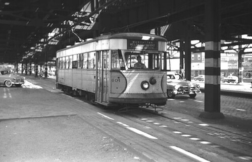
I've been looking at some photos of this operation, which I have a vague memory of riding in 1957 when I was 3 years old. The particular memory is boarding and detraining at the underground terminal at the Manhattan end of the bridge, more so than the actual ride on the car across the bridge.

For the Welfare Island station on the eastbound line (south side of bridge), it appears that passengers has to climb a staircase which took them over the top of the lower level roadway to a station on the westbound line on the north side of the bridge where they could board the elevator down to ground level. Is this correct?

For the east end of the line at Queensboro Plaza, was there:

a. A loop track?

b. A single dead end tail track where the eastbound car would arrive from a track on the south side of the plaza, detrain passengers, the motorman would change ends and adjust the trolley poles, passengers would board and the car would then depart westbound using a track on the north side of the plaza?
 #699007  by JimBoylan
 
Changed ends on the Queensboro side, but I thought the pedestrian crossover was an underpass under the lower level. There was another station near the Queens shore, was that arranged differently?
 #699030  by jhdeasy
 
JimBoylan wrote:Changed ends on the Queensboro side, but I thought the pedestrian crossover was an underpass under the lower level. There was another station near the Queens shore, was that arranged differently?
Thanks for the response.

I've looked at the photos again. These are 4 photos of the Welfare Island station on the eastbound track located on the south side of the bridge.

http://www.nycsubway.org/perl/show?46225
http://www.nycsubway.org/perl/show?46222
http://www.nycsubway.org/perl/show?46216
http://www.nycsubway.org/perl/show?46238

It does look like there is a stairway leading down to an underpass under the lower level which could take passengers to the elevator on the north side of the bridge. However, I also see a stairway leading from the station up to the upper level of the bridge, which makes me wonder if there was a pedestrian walkway on the southside of the upper level of the bridge?
 #699077  by CarterB
 
"Down" stairway photo:
http://www.davesrailpix.com/nyc/htm/qb19.htm
Queensboro Plaza:
http://www.davesrailpix.com/nyc/htm/qb23.htm
http://www.davesrailpix.com/nyc/htm/qb24.htm

Bridge ramp:
http://www.davesrailpix.com/nyc/htm/qb28.htm
http://www.davesrailpix.com/nyc/htm/qb33.htm
http://www.davesrailpix.com/nyc/htm/qb10.htm
http://www.davesrailpix.com/nyc/htm/qb15.htm

"As opened in April 1909, the upper level had two sidewalks with stringers for a future elevated line down the middle, and the main lower level had a roadway for automobiles across the same space, with a streetcar track on each side, and another streetcar track on each side outside the main bridge trusses.

Photos of underground 2nd/59th terminal: (pages 74-79)
http://books.google.com/books?id=Zh2gPd ... t&resnum=4

Elevator building (which even had a top floor emergency room) http://astoriahistory.smugmug.com/galle ... F8V/Medium

At the Manhattan bridge terminal was an underground loop terminal of five tracks located on the east side of 2 Ave between 59 St and 60 St. The corresponding Queens terminal was a loop of three tracks on the street surface in the bridge plaza on the west side of Jackson Ave (Northern Boulevard). "

"When the Third Ave system cancelled their service, the New York and Queens County was rerouted to the outer tracks, clearing the main lower deck for a roadway without tracks. The New York and Queens County and its successor Steinway Lines continued to operate over the bridge by a series of temporary agreements. In the meantime, a second Queens company, Manhattan and Queens Traction, opened a completely new trolley line over the bridge and out Queens Boulevard to Jamaica, in 1913."

"The trolleys also stopped at two other stops on the bridge: one above Vernon Boulevard in Long Island City, the other above Roosevelt Island. From these stations, trolley riders descended a small staircase to a catwalk underneath the roadway, where they entered an "upside down building" (the entrance was on the roof) in which they took elevators to street level. Trolley service ended with the completion of the Roosevelt Island Bridge in 1955. The old elevator buildings were demolished in 1970." In 1930, four vehicular elevators service began between the lower deck of the Queensboro (59th Street) Bridge and the island for vehicular traffic.

"The supporting piers on the island originally included stairways and elevators. Later, an even larger elevator structure was erected. Transports, some with patients and their medical attendants or with inmates and their keepers, would be lowered from the bridge roadway, or raised to it."


See: http://www.nyc10044.com/wire/2014/schetlin.html about halfway down for photo of elevator building and description of the "hanging" walkway to the trolleys.
 #699249  by Leo Sullivan
 
On the Queens end of the line, by the time I got there, the line terminated in a single track stub.
i wasn't yet knowledgeable enough to look for the remains of loops etc. so, can't say what was there
long ago. The terminus had been a long crossover between widely spaced tracks and, they just
cut off the part they didn't need. There was only the one active switch in Queens. The terminus in Manhattan was still as described and, there was a sort of cage where there was a pit and, I think there was a work car kept there too.
LS
 #708223  by keyboardkat
 
My dad grew up in Jamaica, Queens, and remembered the construction of the Independent subway along Hillside Avenue. He said that the Queensboro Bridge trolley was the last surviving remnant of a trolley line that went all the way to Jamaica, but it was rendered redundant by the opening of the subway in the '30s. He also said that in those days, the neighborhoods in Queens along Queens Boulevard and Hillside Avenue were actually seperate villages, with woods in between. He said that you actually knew when you went from Jamaica to Hollis. It wasn't one megalopolis as it is today.
 #711589  by dlagrua
 
The way I understand it, the Queensborough Bridge Trolley was accessibible from Welfare island (Roosevelt Island now) by an elevator on the East Bound side and the underpass under the raodway was used by pedestrians wishing to use the Westbound trolley. The elevator facitities and the elevator itself were big as they were also used to bring automobiles and ambulances from and to the Island. It must have been quite an operation as the only access to the Island was via those elevators.
 #711592  by CarterB
 
Anyone have photos or links to photos of the actual Welfare Island elevators? or the entrance to same on the Bridge?
 #722638  by jhdeasy
 
dlagrua wrote:The way I understand it, the Queensborough Bridge Trolley was accessibible from Welfare island (Roosevelt Island now) by an elevator on the East Bound side and the underpass under the raodway was used by pedestrians wishing to use the Westbound trolley. The elevator facitities and the elevator itself were big as they were also used to bring automobiles and ambulances from and to the Island. It must have been quite an operation as the only access to the Island was via those elevators.

My remembrance is that the Welfare Island elevator was located on the north (westbound) side of the bridge.

http://www.nycsubway.org/perl/show?46215

I believe this undated photo shows car 605 westbound on the north side of the bridge crossing the ramp between the lower level roadway and the elevator to Welfare Island.

Notice the car's route/destination sign reads "1 Butler Street" ... perhaps that is one of the routes/destinations from the car's former owner in Massachusetts?
 #731570  by Montclaire
 
From my post on the Electric City Trolley Museum:
The chassis of Scranton car 505, an Osgood-Bradley electromobile, is still rotting away at Rockhill. From what I can gather, ECTMA members stripped the car of just about everything they could, but the chassis and trucks have been left behind. There is some confusion as to what will happen with the car, some have told me the car is too far gone, but updates on the ECTMA site say they had acquired a copy of builders drawings for the car in 2007, and parts from Queensborough Bridge Railway 601 in 2009. I suppose the worst part of this story is that car 505 was saved by the Rail City Museum in the 50's, in what looks to have been full working condition, but neglect over the years has reduced it to nearly nothing. 505 was one of two Scranton Transit cars to make the final run on the line in 1954. I'm thinking of lobbying to have 505 (what's left of it) brought to Scranton and preserved at least under cover to keep it from getting any worse in case it is ever decided that it can be saved through donor parts or another chassis. 505 is one of only two Scranton cars known to survive, not counting a sweeper car.

Queensborough Bridge car 601 as operated

Image

601 as it appeared in 1989

Image

601 shortly before being parted

Image


Scranton Transit 505 today

Image

Link from Rail City with photos of 505
http://www.railcitymuseum.com/RCHM_v.11 ... mpany.html
 #858151  by Jeff Smith
 
Some interesting facts:

http://www.nycroads.com/crossings/queensboro/

http://www.columbia.edu/~brennan/abandoned/qborobr.html

I love this bridge; I played softball under it on a clay field right at the edge of the bridge abutment circa 1992-1996.
The original configuration of the bridge allowed for the following roadway configuration:

Two elevated railway lines were provided on the north side of the upper level. Service on the IRT elevated lines began in 1917, providing connections from the IRT Second Avenue elevated line to Astoria (via the current N line) and Corona (via the current #7 line). The bridge's elevated railway tracks were removed in 1942.

Two trolley lines were provided on the outer lanes of the lower level. The trolley service, operated by the Queensborough Bridge Railway, went back and forth between stations at each end of the bridge. The trolleys also stopped at two other stops on the bridge: one above Vernon Boulevard in Long Island City, the other above Roosevelt Island. From these stations, trolley riders descended a small staircase to a catwalk underneath the roadway, where they entered an "upside down building" (the entrance was on the roof) in which they took elevators to street level. Trolley service ended with the completion of the Roosevelt Island Bridge in 1955. The old elevator buildings were demolished in 1970.

Six vehicular lanes were provided: four lanes in the center of the lower level, and two lanes on the south side of the upper level. In 1957, after the old elevated railway and trolley tracks were removed, the roadways were reconfigured to allow eleven lanes for vehicular use (seven on the lower level, four on the upper level). The center five lanes of the lower level had a traffic light above the middle lane to regulate traffic flow. During the 1980's reconstruction, the center of the lower level was reconfigured to four wider lanes and a median barrier (where none had existed before), bringing to total vehicular capacity to ten lanes.

Finally, walkways for pedestrians and bicyclists were provided.
 #1012895  by jhdeasy
 
jhdeasy wrote:I believe this undated photo shows car 605 westbound on the north side of the bridge crossing the ramp between the lower level roadway and the elevator to Welfare Island.

Notice the car's route/destination sign reads "1 Butler Street" ... perhaps that is one of the routes/destinations from the car's former owner in Massachusetts?

I've stumbled upon the answer to my own question.

http://www.davesrailpix.com/odds/ma/htm/nubed15.htm

Here is photo of car 604 on the New Bedford (MA) Union Street Railway with a "1 Butler Street" route/destination sign displayed. So it appears that Queenborough Bridge Railway put some of the cars in service before they replaced their route/detination signs.
 #1013833  by frank754
 
Nice thread with some really great photo links all in one place. I'm going to keep an eye on this. I was 3 when it was discontinued, and though it was the last NYC line, there were a few in Brooklyn until just about a year before, most notably Church Ave.
 #1014181  by jaystreetcrr
 
I've just gotten interested in collecting transit tokens and scored a Q'boro bridge token the other day off Ebay. Nice big brass one with a picture of a trolley on it. Most people are familiar with the subway tokens but B & QT also used tokens and it seems like every podunk trolley or bus line had their own tokens.
 #1017690  by jhdeasy
 
http://world.nycsubway.org/perl/show?46229

The caption of this photo says the location is the Manhattan Terminal of the Queensborough Bride Railway.

However, I am having a hard time determining exactly where this car is situated in Manhattan. The terminal was underground. As I remember that area, neither the westbound downgrade ramp from the bridge's north side to the terminal or the eastbound upgrade ramp from the terminal to the bridge's south side would provide this view. ??