• NYC Trenton Falls bridge abutments

  • Pertaining to all railroading subjects, past and present, in New York State.
Pertaining to all railroading subjects, past and present, in New York State.

Moderator: Otto Vondrak

  by Kuyahoora Valley
 
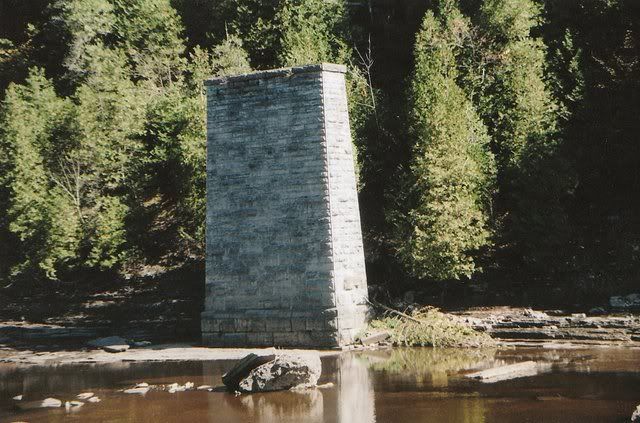
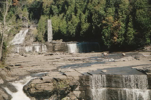
Here are some recent shots of the old Adirondack and St Lawrence, later NYC, bridge abutments in Trenton Falls. The bridge was removed during WWII and sold for scrap. This area is rarely accessible and has been in an area controlled by a Power Company (was Naigera Mohawk) and is subject to trespassing. Recently a hiking trail has been opened into the gorge and it can only be accessed a couple of weekends a year, at the end of Trenton Falls Road. This area is about 10 miles north of Utica. The tracks removed in the 1930s were between Prospect and Poland. The rails were later removed between Herkimer and Poland in the late seventies.

Pictures of the bridge can be found in Fairy Tale Railroad on page 159. The stonework is still in excellent shape.

Image

Image

  by Mark_K
 
Nice pix.

Is any of that line rail-trailed or being considered for it?

  by Kuyahoora Valley
 
No, but there are a few areas between Poland and Herkimer that are used by ATVs. Between Poland and Remsen the ROW is either overgrown or has been obliterated in some places. It's still possible to see the fill that used to be Beecher Trestle, and the tunnel over Beecher Road, as well as a nice long fill along Norris Road. Eastern Rock, now Hanson Materials, removed a lot of the area where the ROW was north of Gravesville. The Hanson Poland plant actually uses the ROW as their access Rd. Most of the bridges south of Poland over the West Canada are still in place however. The bridge over Cold Brook Creek in Poland washed away in a flood in the early 80s. The station still exists in Poland, and is now owned by a fence company. It's very hard to tell where the ROW crossed Simpson Rd, Dover Rd, Trenton Falls-Prospect Rd, and Rt. 365, but south of Poland it's still pretty easy to trace since the tracks were in through the late 70s.

  by Kuyahoora Valley
 
Yes, that's it. Trenton Falls used to be a huge tourist destination in the 1800s. That was before the hydroelectric dams were added. It's still pretty scenic but has been posted for years by the Power Company. Many people have been killed in falls or diving accidents over the years.

If you zoom out a little and follow the ROW to the west, you can see where it approaches and then diverges from the existing MA&N/Adirondack Scenic. Follow it a little more and you can see the wye where Prospect Junction used to be, with the spur heading off to the Northeast to Gang Mills (Hinckley) and Northwood. Much of that ROW is now under Route 365.

It's pretty easy to follow the ROW all the way into Remsen. The existing Remsen water tower was along this ROW, which is why it appears to be so far from the existing tracks.

  by RussNelson
 
Wye at Prospect? The current 7.5' topo only shows a curving track from the Hinckley branch north to Remsen. Ahhhh, but the old 15' topo shows a wye, okay.

Northwood? Kudish and the old USGS 15' topos show the Hinckley terminating at Hinckley.

I'm all ears!

  by Kuyahoora Valley
 
Sorry, I was a little confused. Another book I have talks about a factory in Northwood shipping out 10-12 cars per month around the turn of the century. Turns out the route was originally supposed to go to Noblesboro, but was surveyed to Northwood. The line did in fact terminate in Hinkley. So they must have transported the goods to Hinkley and then shipped by rail.

There was one other spur in Prospect, just south of the wye, which went to the quarry along the West Canada. I believe that stayed open through the 50s, and trains would come south from Remsen.

Incidentally, Prospect had 3 train stations. One is still standing, but was moved across the road from its original location.