• JW&NW Spurs

  • Pertaining to all railroading subjects, past and present, in New York State.
Pertaining to all railroading subjects, past and present, in New York State.

Moderator: Otto Vondrak

  by pumpers
 
Russ, I will gladly let the pro (i.e. you) take the lead on making the edits.
3 last updates:
1. The CT and the JWNW did actually connect in the Factory Rd (E. Campbell Rd) area where the CT went under the JWNW. See the blowup of the Westfield area on this map from the Western NY rail page I linked earlier: http://www.wnyrails.net/railroads/jwnw/jwn_home.htm" onclick="window.open(this.href);return false; I found the original map source somewhere else on the web too, but now I can't find it. I am not sure if the connection was put in after they had a common owner (Broadhead family) fairly late in life or earlier, and what exactly they used it for. With a common owner, they probably would have wanted to swap cars, etc, when needed. One pesky detail - the maps shows the CT going OVER the JWNW, whereas from my earlier post and the official proceedings, it is clear the CT went UNDER. I'll blame that on a map error.

2. I don't think that big building in the old postcard link of the Portage/Main St's intersection in Westfield with the trolleys in front is the Welch Building after all. The size and number of stories is about right, but the shape of windows and trim is completely wrong compared to the modern Welch building,and I did find an old picture of the Welch building looking more or less like it is today. I looked at old Sanborn maps showing outlines of buildings, and now I have no idea what it was in the old postcard link. Suggestions from the local experts?

3. The JWNW ) interchanged with both with LSMS and the NKP over a long period of time, not simply switching from one to the other as I guessed earlier. Here is a 1915 article about the electrification (interesting in itself) that mentions both interchanges in the introduction. http://books.google.com/books?id=y6dMAA ... ge&f=false" onclick="window.open(this.href);return false;
Then here is list of system-wide NKP interchange activity in 1943 showing JWNW interchange in Westfield (and interestingly direct LSMS/NKP interchange as well).http://nkphts.org/1944databooks/nkp/pages/page_6.html" onclick="window.open(this.href);return false; Lots of sites say there was a very active JWNW / NYC(LSMS) interchange right to the end of the JWNW in 1950. So clearly those Sanborn index overview maps shown in the Western NY rails site are incomplete (which I have commonly found to be the case)
  by RussNelson
 
Makes me wonder if there are any remains of the JWNW's tunnel underneath the NKP. I've seen other trolley tunnels that were just buried and forgotten.

.... There, I've edited OSM to reflect all the changes. I didn't bring the Falconer Branch all the way into Falconer, because I'm sure that it would have gone all the way into Falconer (to pick up the most passengers), and I don't know what the route is.
  by pablo
 
The Falconer Branch, if that's what we'll call it (sounds good to me) was what actually killed the former JC&LE.

I don't have the exact $$$ amount at my fingertips, but the extension to Falconer cost almost half the value of the rest of the railroad, if I remember correctly. There was little to no chance that the line could make that money back.

The former JC&LE, later the JW&NW, was an important line when Jamestown was hopping. The line was able to keep an Erie monopoly from happening. Customers knew that if they got quoted something too high from the Erie, they had the option to head down to the boatlanding (which was still actually receiving boats at the time) and they could get a freight there that would get a car to a different railroad much faster than the Erie could. The JC&LE/JW connected with the Erie at Jamestown and at Mayville with the PRR, and at Westfield with the NYC and the NKP. (I simplified from predecessor roads.) The boatlanding had a robust collection of tracks that can be seen even today; there was a lot of freight getting moved around down there.

It's worth mentioning that the Erie and the JC&LE/JW had a solid working relationship. The Erie used the JW facilities for sometime after the JW died, and the roundhouse at the boatlanding regularly serviced the switchers that the Erie kept around Jamestown. Additionally, the tracks that were south of the Erie main that served the BPU and went into Brooklyn Square in Jamestown were originally JC&LE tracks. They sold them to the Erie and the diamond used to cross the main went away.

So, with all of this, the Erie could conceivably connect with the DVAP/NYC there at Falconer. The DAV was around, and did have a small amount of trackage there; in the early 1900's, there was even passenger traffic. I have never seen the official reasoning, but I'm sure that the JC&LE thought they could get a piece of the Falconer action, and have a "better" or "faster" north-south option than the DAVP (a very minor line), the Erie (who would take you to Dunkirk through a connection at Markhams on the B&SW sub...surely not faster) or anyone else.

Well...it cost too much. The JC&LE couldn't cover the debt.

The Broadheads purchased the carcass of the JC&LE, and renamed it the JW&NW. This gave them both sides of the lake, very popular with the tourists, and this included the Chautauqua Institute and a connection to Panama Rocks. Your tourist destinations were sewed up, and of course, you had the park at Midway. The Broadheads had the Jamestown Street Railway, too, who also used the Boatlanding area for trolley cars, and that line extended along the "main street" into Falconer.

The electrified lines were a one-stop shop to get you in, out, and around at Jamestown. The line that broke off of the main and went up the Moon Brook, the "JC&LE Falconer line", was abandoned shortly thereafter. You can see the ROW around the area in several places.

Edited somewhat for length and simplicity; there's a bit more to it all than just what's up there.
  by thebigham
 
Not sure what JW&NW thread to put this (there's 3), but this has the most posts.

I did not know some JW&NW track still exists in Jamestown. It survived after 1950 to serve a scrap dealer.
You do not have the required permissions to view the files attached to this post.
  by thebigham
 
Did the WNY&P ever operate on the trackage??
You do not have the required permissions to view the files attached to this post.
  by lvrr325
 
The appearance of that spur suggests it hasn't been used in 30 years.
  by BR&P
 
I like that! I have about zero desire to go out and watch mainline trains go by, but would love to see something like that old spur brought back to life. I know, not very likely, but we can dream can't we?

(Want to get the neighbors riled up? Put on a vest and hardhat, get a clipboard, and wander around as if measuring etc. Tell anybody who asks they're going to reactivate it for switching every night! :wink: )
  by sd80mac
 
BR&P wrote:I like that! I have about zero desire to go out and watch mainline trains go by, but would love to see something like that old spur brought back to life. I know, not very likely, but we can dream can't we?

(Want to get the neighbors riled up? Put on a vest and hardhat, get a clipboard, and wander around as if measuring etc. Tell anybody who asks they're going to reactivate it for switching every night! :wink: )
Use vest and hardhat with CSX logo.... give them a hell with tons of phone complaining.. hahahahaha
  by pablo
 
I'm unsure about the first few pics, where it goes under a bridge, but it appears to be trackage under the Third Street bridge.

That whole area has some complex history, which I'll try to summarize quickly:

Originally, there was a diamond in that approximate location, that crossed the Erie and went to the South side of the main there and covered quite a few customers in what used to be known as Brooklyn Square, I haven't checked for some time, but there were rails still in the dirt at the current Chautauqua Brick hardware store yard that were from all of this. This stub would have come within spitting distance of the former Warren and Jamestown trolley terminus in Brooklyn Square but I do not know if there was ever a connection. It stands to reason that there would have been a passenger connection from those coming from Westfield and Mayville, and wanting to go south...but at the time, they would have been better served taking the Pennsy south into Corry, PA or the DAVP/NYC from Fredonia into Warren, PA, if someone wanted to.

The Erie did not want the diamond, and it was purchased from the JC≤ the smaller railroad kept the line north from what was the diamond (more in a moment) and the Erie, who had a robust yard in the area covering from this line in Jamestown to the DAVP in Falconer, and everything in-between, now switched this area south, including delivering coal to the power plant.

The diamond was removed, and the track re-aligned so that you now got to the Boatlanding (where that final picture was taken) along the spur I think you shot first. This was the way you would transfer freight between the Erie and the JC&LE, and later the JW&NW. The JW electrified the line until 1947, so I don't think that they could even come into the Jamestown yard. I believe that the Erie brought freight to the JC&LE/JW at the Boatlanding. In fact, the Boatlanding was the enginehouse for the JW. In decades past, when the line was still the JC&LE, there was even a roundhouse north of your final picture, which I have found on maps.

In 1947, the JW dieselized with a pair of 70-tonners and ran until 1950. There was a good patch of customers at the boatlanding, and there's still track in a bunch of places down there. After the JW folded, the Erie took over and used the Boatlanding as their diesel house for the Jamestown-area switchers. I assume this continued until the Erie or Erie-Lackawanna built their own diesel house which still exists today next to the passenger station.

I do not know how long freight was served at the boatlanding location by the Erie. I vaguely remember reading someone say Conrail went in there at some point, so the track was "good enough" for that. I do believe that only four axle switchers could go in there, so that might be a clue regarding the date of last service.

NS never went in there, and neither did the WNYP. I couldn't say for sure, but I don't think there's been a customer that would need service there for decades. The closest it might have come are shipments to the Power Plant that I have witnessed personally: heavy equipment for the plant right before the WNYP, and coal shipments offloaded by backhoe during the WNYP. A scrap dealer wanted to locate there, and would likely have brought in a lot of traffic, but the city denied it for nefarious reasons...and that whole area remains a wasteland today.

Dave Becker
  by thebigham
 
^Thanks, Dave! I knew you would know.
  by lvrr325
 
Looking at Google Maps I see a bridge with rails still on it going into the power plant, crossing the Chadakoin next to W. 2nd Street.
  by pablo
 
I believe that the bridge is still there, though I haven't been in there for a long time. Between not living in J-Town and no longer working for the railroad, there's no reason to go down there. I'm also not sure where the tresspassing would begin, and what exactly is public land.

That bridge, I thought, was slated to be removed. There were some ideas to continue the Riverwalk (the perpetual boondoggle to add a few hundred feet per decade to a walking path that few people use) somehow over the WNYP/NS and to connect to the Boatlanding, and then perhaps continue further.

I believe that there was even a proposal some time ago to continue the path into a sort-of hybrid rail trail that would follow the old JW line towards Bemus Point. No clue how far it would actually get, as the ROW of the JW was purchased, almost immediately, by property owners adjacent to it, since the JW was prime real estate on the north shore of the lake. Some stretches of the JW, especially obvious near Midway State Park, have been turned into roads that are well-used.

I can't tell you where this rail trail proposal is, as far as progression, because nothing has happened. If they ever lift those rails you saw in the most recent pictures, I would assume that's when you know they're serious. However, this path would begin...at the station(-ish?) and then lead to...the middle of nowhere. There's a park along Washington Street that is kinda close to it...but still a good quarter mile off of the alignment for the JW. There are significant brownfields up there, too...and not to mention you'd be within spitting distance of a major scrap dealer. Feel free to walk around and check out what the ground looks like where water has flowed.

As far as the bridge, if I can dig the maps up, the line that goes to the plant continued past the plant (through it basically) and to the rails in the ground at Chautauqua Brick. The BPU power plant is exclusively natural gas these days, I believe, so I don't know that they get coal anymore. If the coal is still getting shipped in, it's a truckload at a time; that is where the WNYP was using a backhoe to offload it under the Third Street bridge. I am certain that that bridge at the Power Plant is no bueno for rail traffic, and that's been the case for some time.
  by pablo
 
OK, you all like pictures, right? Everyone likes pictures!

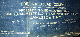
So, I'm going to add some. I dug into my pile of stuff and found a val map from 1941. This has to be a proposal to purchase or lease the JW trackage in Jamestown. I mean, I know what it says, but some of the line had not been served by the JW for some time, as it was electric. I am confident that this map is essentially a "wish-list" for the Erie at the time. In December, of course, we went to war, and the passengers traveling to Westfield (NYC/Nickel Plate) and Mayville (Pennsy) to get on passenger trains the Erie couldn't saved the JW for another 9 years.

This map is large: you'll need to scroll, and I apologize for that, but the map is more than 5 feet long, and even with the pic above, I had to do it in parts. This is the Boatlanding, with text added on the map. I can answer more if anyone has questions. I linked to my Blogger I use only for image storage. At the link below, you can save it and zoom in as you need to. Sorry for making you make an extra step.

https://reddymcredred.blogspot.com/2017 ... nding.html

Dave Becker
  by pablo
 
This is the legend to the whole map. This happens to be sheet 1 of 4: if this val map is to be believed, the Erie was considering buying not just the trackage in the previous post, and what I'll show you next, but lines torn up that would have connected with the DAVP/NYC in Falconer, which the Erie already did. So, like I said...I think this whole thing was wishful thinking, by someone.

Image

Dave Becker
  by pablo
 
Same deal: linked to a page that has the full image linked, because it's too big.

I forgot that they unloaded coal across the river and used a conveyor to bring coal to the plant. Now it makes a lot more sense.

https://reddymcredred.blogspot.com/2017 ... hside.html

Dave Becker