• The NYC West Shore Thread

  • Pertaining to all railroading subjects, past and present, in New York State.
Pertaining to all railroading subjects, past and present, in New York State.

Moderator: Otto Vondrak

  by NYCUticaSyracuse81
 
I recently purchased this postcard online, and was wondering if anyone knows the exact whereabouts these underpasses were located on the W.S. in Mohawk, NY?

Thanks, Cnyrailroadnut
You do not have the required permissions to view the files attached to this post.
  by WShore4Ever
 
Great find!
The two overpasses are likely just west of where the the Thruway (I-90) crosses the WS RoW east of Mohawk. This would be near N43.014636, W-74.981505. The WS is in a cut at this location. Milepost 216. The near bridge is for Putts Hill Road. The far bridge is an earlier alignment of Putts Hill Rd.
From GoogleMaps:
Putts Hill Google.jpg
The near bridge would have been iron/steel by the time the Thruway was built in the 1950s. View is looking SE.
Putts Hill Thruway.jpg
The far bridge is shown on the NYC Valuation maps as removed by 1917.
Putts Hill Valuation.jpg
You do not have the required permissions to view the files attached to this post.
  by WShore4Ever
 
Hikeable? Legal? Probably, but save your time for other treks. There are no bridges, just a weed-filled cut. Putts Hill Rd is now fill as is the Thruway overpass. A better spend of your time is the bike path on the WS RoW (technically a rail-trail?) down at Little Falls: serious rock cuts, rough ashlar retaining walls, Barge Canal Lock 17, Erie Canal Lock 36, potholes on Moss Island, good food on Anne St, old mill buildings and more, maybe even a view of a CSX or Amtrak over on the Chicago Main across the river.

BTW, Found this photo from the NYS Archives of the crushed stone works that is now a colonnade of pillars along the WS:
LF Stone Co. From Across Mohaw RIver.jpg
Here is the standard post card photo of the same.
LF Stone Co. Post Card.jpg
The WS ran between two structures, the main storage building whose pillars remain today, on the uphill side and another narrow building between the WS and the Erie Canal that was used for storing (bagged?) cement, a by product.
You do not have the required permissions to view the files attached to this post.
  by WShore4Ever
 
I should have checked. They made bricks, not cement, with the stone dust.
From the 1918 Sanborn Map:
LF Crushed Stone Sanborn 1918.jpg
You do not have the required permissions to view the files attached to this post.
  by lvrr325
 
There really is nothing to hike except an overgrown cut from the Thruway to Putts Hill Road and then for a ways west of that. A washout developed and they just cut it for the small stream perhaps 100 yards west of the bridge location and once you get up to within about the same distance east of the Rt. 28 interchange, the ROW is wiped out with 5S on top of it.

Now to the east of the Thruway a section is serving as some kind of trail, complete with bypass around a destroyed culvert on NYS Thruway property, but it appears to be for power lines. And that only lasts until the driveway for Lock 18.

As close as I can tell the first place it can legally be hiked is starting east from the NY-167 crossing in Little Falls.
  by NYCUticaSyracuse81
 
I checked on the area at Putts Hill Rd. A few days ago. Heavy overgrowth, but there were two large poles cemented on each side of the ROW, one of which had snapped from its base. Anyone know what they were used for. My guess was for a pedestrian bridge over the tracks?
You do not have the required permissions to view the files attached to this post.
  by Fireman43
 
SST - on page 6 of this thread you posted some pics of the WS as it goes through Akron and mentioned the tracks have been pulled up. When I briefly checked out this overpass Rueben and Bloomingdale in the early 90's I do believe the rails were still in place. I may be mistaken but I thought odd until I thought as this runs thru the reservation maybe that had something to do with them being untouched?

On another note on this stretch of ROW - if you follow the ROW east over Rt77 at Basom a ways to Kenyon Road into Genesse County-
https://www.bing.com/mapspreview?osid=6 ... orm=S00027" onclick="window.open(this.href);return false;

there is a fairly large area of ballast. I always wondered if may have been sidings for cars from Buffalo Crushed Stone or other customers.

Sorry if the link didn't carry - for some reason I'm unable to cut and links from Bing.

thanks

Mark
  by BR&P
 
NYCUticaSyracuse81 wrote: Heavy overgrowth, but there were two large poles cemented on each side of the ROW, one of which had snapped from its base. Anyone know what they were used for. My guess was for a pedestrian bridge over the tracks?
My guess would be telltale poles.
  by Old & Weary
 
The area of stone is the location of a ballast loading area and siding put in around 1980. If you scroll the map photo directly down along Kenyon Avenue, you will see a stone quarry which was the source of the product. Not much is currently going on at the quarry and I am not sure if it is still active. For a couple of years, carloads of ballast were loaded with a front end loader at this site after being trucked from the quarry. For a couple of years, large amounts of ballast were shipped out of here with six axle units sometimes being sent down for loads and other times pulled by the local from Oakfield to Frontier. After a couple of years, shipments abruptly stopped. I heard at the time Conrail had promised the quarry extensive business so the quarry undertook the expense of grading the area and putting in the siding only to have the railroad later sign a ballast contract with another quarry and leaving them out to dry.
  by Fireman43
 
Thank you - never was aware of that quarry - just jumped the conclusion the ones up in Lancaster were 'it'.
I know somewhere there is an abandonment list of this line someone put together but by 1980 or so was the line cut off at Oak field ?
Can still remember in the late 50's riding though Elba but remember the warehouses that were there loaded with cabbage - would they have loaded cabbage by rail from there?
  by Old & Weary
 
The section from Byron to Chili Junction was abandoned 1/1/1960. The next section to go was from Oakfield through Elba to Byron in late 1963 or early 1964. About the only traffic from Byron was a small feed mill. I have a vague memory of seeing some reefers in Elba about the time I could tell they were different from boxcars but I really don't know how much shipping was done by rail by that time. The Elba area also produces a large amount of onions which could have filled carloads along with cabbage just as they are shipped out by truck today. In the early Eighties, due to a poor harvest, one of the Elba producers was short and had some Texas onions shipped by rail to Oakfield so he could honor his contracts.
  by SST
 
Fireman43 wrote:SST - on page 6 of this thread you posted some pics of the WS as it goes through Akron and mentioned the tracks have been pulled up. When I briefly checked out this overpass Rueben and Bloomingdale in the early 90's I do believe the rails were still in place. I may be mistaken but I thought odd until I thought as this runs thru the reservation maybe that had something to do with them being untouched?

On another note on this stretch of ROW - if you follow the ROW east over Rt77 at Basom a ways to Kenyon Road into Genesse County-
https://www.bing.com/mapspreview?osid=6 ... orm=S00027" onclick="window.open(this.href);return false;

there is a fairly large area of ballast. I always wondered if may have been sidings for cars from Buffalo Crushed Stone or other customers.

Sorry if the link didn't carry - for some reason I'm unable to cut and links from Bing.

thanks

Mark
As far as the crossover mentioned above, I have no idea if any rails are up there. Never walked it. As for the immediate area of Akron, no rails for several miles out. I never walked that line east of the smoke shop mentioned in my previous post so I can't verify beyond that for several miles.

As far as Oakfield, no rails either. Just the ties in the ground right in town. There are no rails west of Oakfield for several miles as I drove on the ROW. Just ballast maintained by the snowmobile group. Further west of that, overgrowth and water with some areas backfilled probably to replace bridges.

But that section east of Akron and west of Oakfield, maybe, maybe not. It looks like too much private land to gain access.

As far as Oakfield east? No clue as I never checked out that section.
  by charlie6017
 
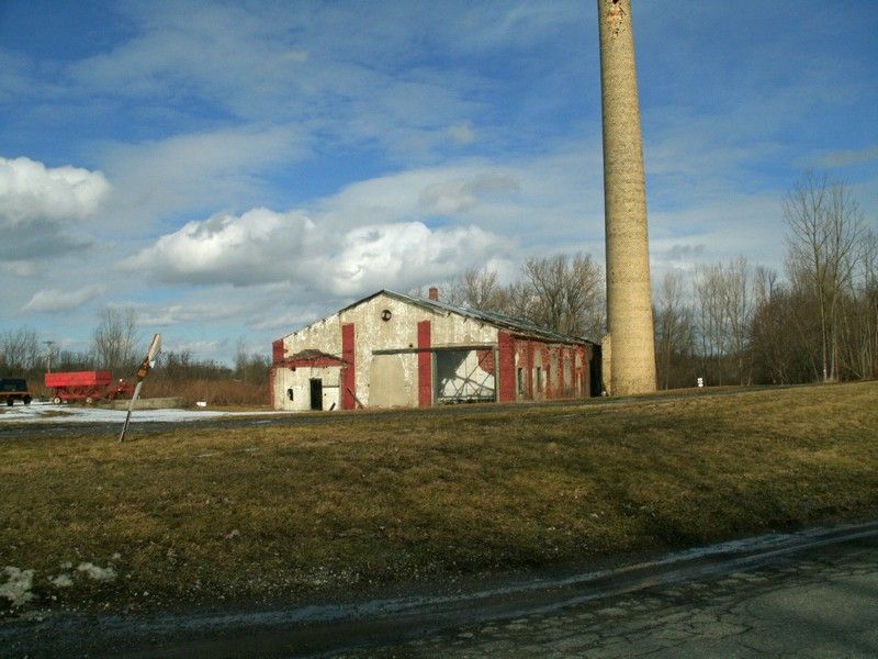
For those unaware, there's what I'm guessing was a storage area/warehouse for the West Shore
still standing in Elba on Ford Rd., just off 262 on the east side of Rte. 98. It looks horrible and I would
assume it won't be standing a lot longer. Also there's a smoke stack still in place next to it.

Charlie

Image
  by charlie6017
 
Also, here's a screen-capture of an overhead shot, thanks to Bing Maps.

Charlie
You do not have the required permissions to view the files attached to this post.
  • 1
  • 4
  • 5
  • 6
  • 7
  • 8