• NS crossing at Letchworth State Park

  • Pertaining to all railroading subjects, past and present, in New York State.
Pertaining to all railroading subjects, past and present, in New York State.

Moderator: Otto Vondrak

  by SST
 
Here are some photo's and 2 links while I visited the area today. No trains over the bridge although I kept looking.

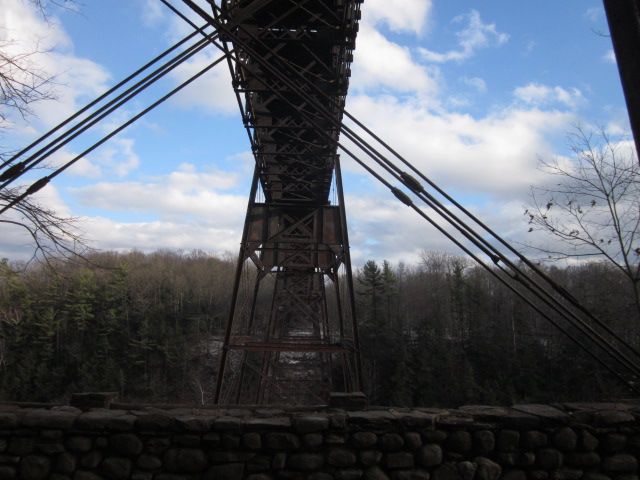
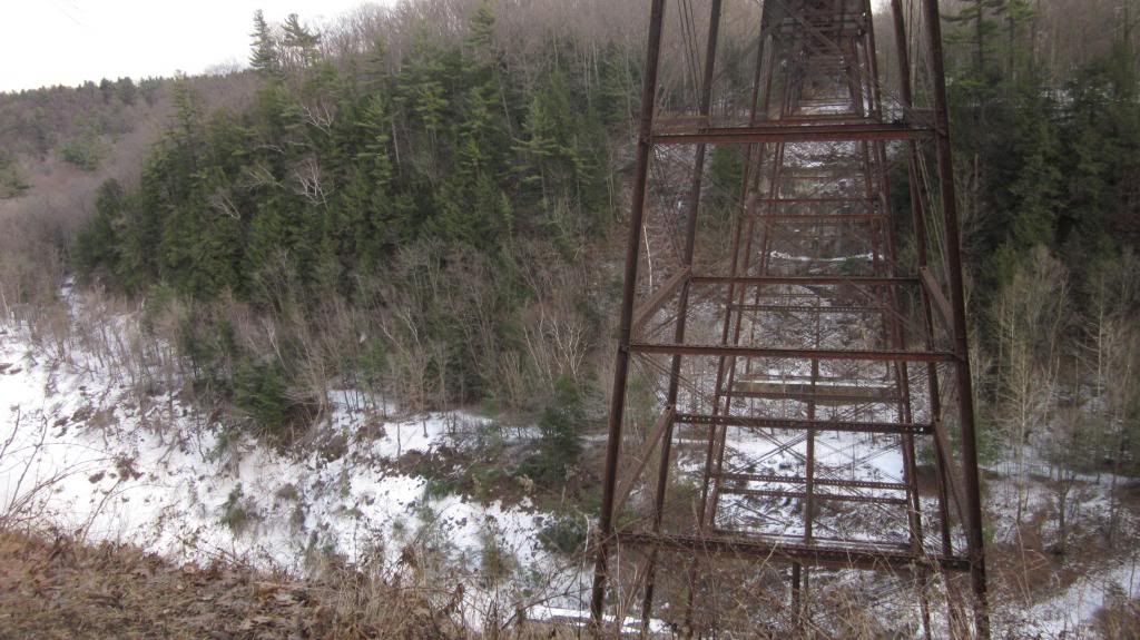
This first picture is while I passed underneath the bridge. The visitor center said to expect icy roads but they were well salted and mostly dry. No problems. Good to see the bridge still standing.
Image

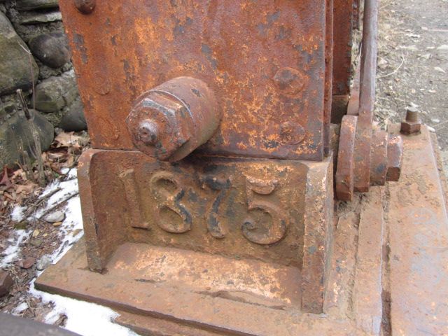
I noticed today that 1875 is at the base of each leg of each tower. They looked in good shape. I do remember at least 10 years ago or so, when my friend and I explored the other side along the PRR/canal. I seem to remember that the base of 1 or 2 legs were not in that good of condition. I am going to explore that side come this summer.
Image

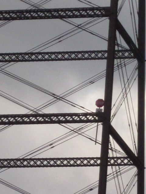
While at the base of trail #1 and as I looked up at the bridge, I saw something on one of the legs half way up. Gee, that looks like a stop sign. It is, and I think it was taken from the east side of the trestle. Below the stop sign it says, "Private Railroad" or something close. I wonder who did it. NS repair crew or somebody else.
Image

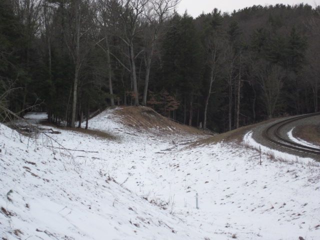
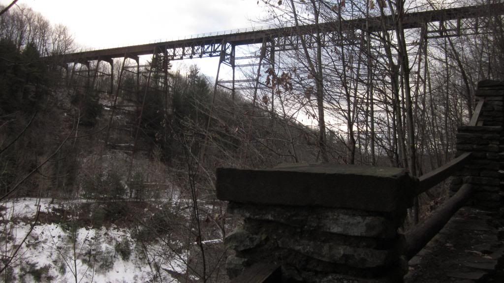
I think this has been discussed before and probably on the previous forum. I don't remember the outcome of the discussion. This picture shows the NS line on the west side of the river crossing and I think the original ROW on the far left of the picture enhanced by recent snowfall. Is this an original ROW? BTW I didn't jump the fence. There isn't any further up. I stayed on the snowmobile trail. {oh, am I allowed to say snowmobil on here?}
Image

These two links are large pictures and I didn't want to spend the time to resize them.

In this picture, you can see the ex- PRR/canal/Greenway Trail on the other side. My friend and I started from Nunda and rode all the way in. The land slide area was not fun to cross. I may try from Portageville via snowshoe when the snow pack returns. Letchworth cabins are also along this trail just north of the NS line but before the land slide. I'm surprised another slide hasn't happened.
http://i1131.photobucket.com/albums/m55 ... 8e8421.jpg" onclick="window.open(this.href);return false;

This picture is just a large wide angle photo capturing the whole trestle.
http://i1131.photobucket.com/albums/m55 ... 6dfa94.jpg" onclick="window.open(this.href);return false;
  by lvrr325
 
Current bridge is the second or third at that location. Empty ROW is likely for the original bridge.
  by nessman
 
lvrr325 wrote:Current bridge is the second or third at that location. Empty ROW is likely for the original bridge.
Actually it's an old road...

http://docs.unh.edu/NY/ptag05se.jpg" onclick="window.open(this.href);return false;
  by nessman
 
SST wrote:In this picture, you can see the ex- PRR/canal/Greenway Trail on the other side. My friend and I started from Nunda and rode all the way in. The land slide area was not fun to cross. I may try from Portageville via snowshoe when the snow pack returns. Letchworth cabins are also along this trail just north of the NS line but before the land slide. I'm surprised another slide hasn't happened.
I've crossed that landslide area before in spite of the warning signs saying not to!
  by ctclark1
 
Second bridge, built in just under 2 months after the original wooden trestle burnt to the ground only 24 years after opening. It used the original piers in the river which accounts for some odd spacing with the support structure. (Edit: It also explains the one long pier, which when I saw an image of the original trestle a few years back I had one of those OH! moments because growing up I had always wondered why one of them was insanely long... That image is available on Wikipedia)

I don't remember the exact outcome of the discussion on the old ROW there. It was in the thread about replacement of the bridge. I do know the "new" alignment breaks off the original alignment north of Denton Road (fairly obvious curve in what was an otherwise straight-as-arrow track, also still visible to a point on topo maps). I think someone discussed drainage as a possibility as most of the ROW was in a pretty decent cut as it approached the bridge (also pretty obvious on current topo maps). Based on historic county maps, it was sometime between 1866 and 1902 so it could've been with the new bridge, I'd need to find some more maps in between those years to compare. Other than taking the opportunity in 1875 when the bridge was out to make the change, I don't see the bridge itself being the reason for the realignment, I would guess there were other problems that they discovered during the first 24 years of using the line.
Last edited by ctclark1 on Sat Jan 18, 2014 1:12 am, edited 1 time in total.
  by ctclark1
 
nessman wrote:
lvrr325 wrote:Current bridge is the second or third at that location. Empty ROW is likely for the original bridge.
Actually it's an old road...

http://docs.unh.edu/NY/ptag05se.jpg" onclick="window.open(this.href);return false;
If it was a road, it was after it was a ROW, there are maps from 1853 and 1866 which both beg to differ about it being just an old road. They both correlate with obvious cuts into the terrain still visible on topographic maps at the same location.
  by johnpbarlow
 
Was there any indication of work in progress on NS's new bridge at Portageville?
  by map193
 
ctclark1 wrote:Second bridge, built in just under 2 months after the original wooden trestle burnt to the ground only 24 years after opening. It used the original piers in the river which accounts for some odd spacing with the support structure. (Edit: It also explains the one long pier, which when I saw an image of the original trestle a few years back I had one of those OH! moments because growing up I had always wondered why one of them was insanely long... That image is available on Wikipedia)

I don't remember the exact outcome of the discussion on the old ROW there. It was in the thread about replacement of the bridge. I do know the "new" alignment breaks off the original alignment north of Denton Road (fairly obvious curve in what was an otherwise straight-as-arrow track, also still visible to a point on topo maps). I think someone discussed drainage as a possibility as most of the ROW was in a pretty decent cut as it approached the bridge (also pretty obvious on current topo maps). Based on historic county maps, it was sometime between 1866 and 1902 so it could've been with the new bridge, I'd need to find some more maps in between those years to compare. Other than taking the opportunity in 1875 when the bridge was out to make the change, I don't see the bridge itself being the reason for the realignment, I would guess there were other problems that they discovered during the first 24 years of using the line.
If my memory serves me correctly I think I read in the portageville bridge replacement thread that the reason for realignment was because the old r.o. w was too steep during the steam era and the only alternative was a curvy but flatter realignment that we see today. Here is a link to that part of the thread: http://www.railroad.net/forums/viewtopi ... nt#p975859
  by ctclark1
 
That makes sense as well. I thought about the drainage reason in part because of the stream that now runs through that area, and personally when I walked the old row (years before I even knew what it was) I remember it being rather soggy.

johnpbarlow I don't believe any work has started yet, I'm not even positive they've finalized plans yet because funding keeps going away. I do know they failed to get at least two or three federal TIGER grants for the project.

As far as the stop sign, it's a fairly standard private crossing sign (typically used on private driveways that cross the tracks). My first inclination would be some young'ins thinkin' they's be cool by dropping a stop sign into the water to see what it would do but by very odd chance it instead got stuck in the structure. I doubt it was put there on purpose... or by an NS crew.
  by SST
 
There was no sign of any activity on either side of the trestle.
  by nessman
 
ctclark1 wrote:If it was a road, it was after it was a ROW, there are maps from 1853 and 1866 which both beg to differ about it being just an old road. They both correlate with obvious cuts into the terrain still visible on topographic maps at the same location.
Yes, I stand corrected. Looking at current maps vs the old ones... makes sense.
  by sd80mac
 
We had this discussion few years ago.

the dirt road on left would be former alignment that was straight line from the bridge . When it goes into wood, it veers to north then go straight up the hill and connect to the existing track.

you can see in google map or google earth and see the tree lines showing the former track bed real clearly.

the hill in between the dirt road and track was cut about half size. That hill with a lot of trees was much closer to the track few years ago. At first when i saw that NS were working on this area few years ago, I thought that they were getting the new alignment ready for this new bridge project. When I looked at Google Earth, I could see that they put in stones in the ditch. It is clearly drainage project as ctclark1 mentioned.

It seems that they worked in that area in 2006 (times fly by.. i thought it was "few years") and apparently they redo the area in 2001 by putting in the stones in ditch for better drainage... (you just use "historcial imagery" feature to see couple of pictures to see the changes..)
  by wdburt1
 
Starting at the west end of the bridge, the original alignment went through a right hand curve and then pointed due north to the east end of the curve at Castile. It was a perfectly straight line between the two curves, still visible on topo maps. In the first half-mile or so west of the bridge the original line climbed out of the river valley through a cut that was about twenty feet high near the bottom. When NYLE&W sought to double-track the railroad in the early 1880s, they had to decide whether to widen the cut for two tracks (expensive) while doing nothing to ease the grade, or build a new line winding around the hillside, which avoided the cut and eased the grade. The new line was completed in 1882-83.

Replacing the original straight line with one more suited to the topography required essentially all new construction between the west end of Portage Bridge and the east side of Castile. The new line passes over the old one about a quarter mile east of Denton Corners Road. It is about ten feet higher at this point than the old line. A crumbling stone abutment on the old line is visible in the woods. You can see evidence of the old line each way from Denton Corners Road, about 500 feet east of the grade crossing.

After the new line was in service the railroad constructed a stone dam across the old cut to retain water for fire protection on the new bridge. A system of pipes fed the water down the cut from the dam to the bridge. It was retired in the Fifties.

WDB