• Old Bridge Abutment on NYC ML between Memphis and Jordan?

  • Pertaining to all railroading subjects, past and present, in New York State.
Pertaining to all railroading subjects, past and present, in New York State.

Moderator: Otto Vondrak

  by frankgaron2
 
Hi All:

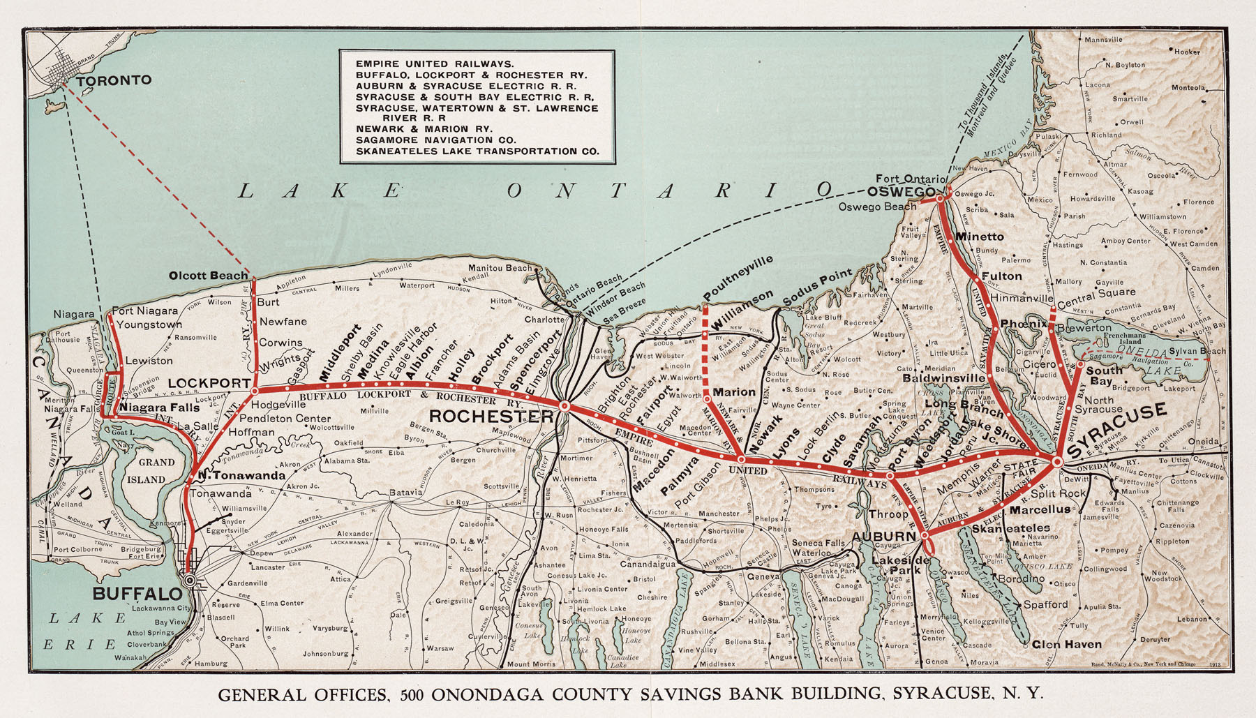
In tracing the former West Shore in this area, I came across a topo map showing a former (railroad?) overpass going over the NYC mainline just north of Pumphouse Road in Peru (between Memphis and Jordan). My 1902 topo doesn't show anything there - no sign of an interurban or anything, and the 1957 topo map shows a former roadbed (?).

Please see the attached map - I've highlighted it in yellow and encircled it in a bold yellow circle. This is not the former West Shore overpass over the NYC mainline east of Weedsport, rather, this is something different.

Any help would be greatly appreciated!

Thanks,

Frank
  by O-6-O
 
The remains of the Interurban line Rochester Syracuse and Eastern.
  by scottychaos
 
It is the interurban line between Syracuse and Rochester.
started in 1912 as the "Empire United Railways", then merged into the "Empire State Railway" in 1917.
Interurban (trolley) cars operated over the line from 1912 to 1931, which fits perfectly with:
My 1902 topo doesn't show anything there - no sign of an interurban or anything, and the 1957 topo map shows a former roadbed (?).
http://en.wikipedia.org/wiki/Empire_United_Railways" onclick="window.open(this.href);return false;

http://en.wikipedia.org/wiki/Empire_State_Railway" onclick="window.open(this.href);return false;

The only maps I could find on-line show it as a straight route:
http://www.lib.utexas.edu/maps/historic ... n-1913.jpg" onclick="window.open(this.href);return false;
but it clearly crossed over the railroads at times, when necessary.

Scot
  by frankgaron2
 
Thanks to all for the assist. I thought it might well be RS&E but couldn't find a good map to confirm. The SPV railroad atlas shows the line running further south of the NYC & West Shore in that area. I'm taking it that the atlas is wrong then?

Frank
  by lvrr325
 
It ran to the south through Weedsport and Jordan, then curved north and crossed over to run along the north side of the two lines.

The ROW is still pretty obvious in a lot of places.
  by roadster
 
Many portions of current Rt 31 follows the row or is actually right on it. (not all of it!! but alot)
  by lvrr325
 
The main stretch that Route 31 uses the old ROW is between Jordan and Weedsport, plus a little strip just east of where this bridge used to be. E/B I-690 along the lake is also on the RS&E ROW.

Past Jordan it's less obvious on the maps, unless again it ran on or in Route 31.
  by roadster
 
I was also referring to areas west of there, towards Rochester. Savannah, Clyde, Lyons, Newark, Palmyra, Macedon. Rt 31 follows a lot of old interurban row through these areas.
  by scharnhorst
 
you can follow the ROW just about from Port Byron to Jordan along RT 31 once you get passed Weedsport on RT 31 near the Millis Truck Station the ROW is just to the South of RT 31 and is used as a Pole Line for a utility company. The Station still stands in Jordon and is now an Auto repair shop.