• Forest Hills-Dedham-Walpole Streetcar Line Questions

  • Discussion relating to commuter rail, light rail, and subway operations of the MBTA.
Discussion relating to commuter rail, light rail, and subway operations of the MBTA.

Moderators: sery2831, CRail

  by Austin023
 
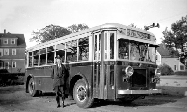
I know there used to be a trolley line (or lines perhaps) that went down Washington Street from Forest Hills via Dedham, Norwood to its terminus at Walpole until the 1930s. Was this operated by BERy? I am curious about this as my grandfather used to mention riding this line out to Walpole from Boston back in the late 20s/early 30s. Did it go the same route as the current 34E bus (Walpole-Forest Hills)?
Did any other lines branch off/merge with it? Did the line interact with any of the rail stations (ie Walpole Union, Norwood Central, etc.)?
Sorry if this subject was brought up before (I searched and found only a few references to this though, years old).
  by 3rdrail
 
Yes, it is the same basic route as the T's service to East Walpole now from the Hills. Historically, it was run by various companies running their equipment to the Boston/Dedham line on Washington Street (that's why Washington Street is so wide), at which point a BERy crew would take over for the run to the Hills via Bellevue Hill, the highest point in the City of Boston. Bay State Street Railway Co. which became Eastern Massachusetts Street Railway Co. in 1919, met the BERy men at the same location as where the Dedham Line bus terminates today (originally at Wash/Grove). An issue arose between the EM and BERy regarding use of the EM's Birney one-man operated "Safety Cars" in which BERy refused to operate them. After a stand-off, EM initiated bus service on their own in 1932, a tradition that remains today, courtesy of the MBTA. There is another thread somewhere with this stuff on it, so a few searches should be rewarding.
Image
  by 3rdrail
 
,,,and here's the rail that they rode on, owned by the Eastern Mass and leased to BERy. This photo was taken on Washington St. Roslindale near Forest Hills recently during a street re-paving.
Image
  by theseaandalifesaver
 
Were most trolly tracks in Boston just paved over and not pulled up? Or was that just a rail that may have happened to be missed?
  by MBTA3247
 
To a large extent the former. There's still miles of track buried just below the surface all over Boston. It's likely to stay there, too, unless a particular road gets torn up all the way to the bare ground for resurfacing (as happened a year or two ago with the part of Washington St by the Dedham line).
  by Austin023
 
hey guys thanks very much for posting these. I have seen glimpses of tracks a few times during road work on Washington St over the years, especially in Roslindale and Dedham. I know the tracks in Norwood center and Walpole were torn up in the 1950s during sewer construction (pictures are in a book on the town histories), but around Boston and Roslindale, Dorchester, etc. there are miles and miles of trolley tracks buried under layers of pavement---I have seen those often during road work as well.
That is interesting about the conflict with BERy and EM...I had assumed the service might have ended due to the construction of the Route 1 in Dedham (the rotary where Washington Street intersects it) as it seems it would have been hard to have a trolley crossing at such a intersection/rotary.
There are a couple of poles in south Norwood that look like they might have been wire poles once, but that has been the only evidence I have seen of the former line past Dedham line. Was there a turn around loop of some kind at the Dedham/Roslindale line area?
  by BandA
 
When they rebuilt Mt Auburn St (MA-16) in Watertown (late 80s or early 90s), they scraped off the pavement and there was a cement road with trolley tracks set in cobblestone. If they had cleaned out the flanges I bet they could have run trolleys it looked so good. They tore the whole thing up and replaced it with asphalt.
  by F-line to Dudley via Park
 
A lot of these former cobblestone-paved streets still have the original road surface under the pavement. It holds up well enough as a roadbed base (not much unlike concrete on highways) that they leave it under the asphalt unless they have good reason to dig it out. So whatever rails were originally laid in the cobblestone stay there. Doesn't make for very easy utility digs, but it keeps the road in robust structural condition.
  by 3rdrail
 
Austin023 wrote: Was there a turn around loop of some kind at the Dedham/Roslindale line area?
That's a "no" and "maybe", I still haven't seen real documentation for a definitive answer to this one. The line originally ended for BERy at Wash/Grove with most likely a cross-over. After that, the line went to the Dedham line and was single tracked from Grove on outwards with a long siding. As far as a loop is concerned, the right of way for one was cut into Wash at Grouse and at Maplewood on the western side of Wash. I have seen this loop represented as an erased double-tracked cross-over siding on BERY's Track Map from 1899-1915 which I possess. Whether or not this was actually ever used for streetcars ????? I know for a fact that it was used as a loop during the reign of the Arborway Division of Trackless Trolleys. So, the best that I can do on that one is a "maybe". If anyone else has a more definitive answer, please chime in, as numerous buffs are interested, apparently. Loops or no loops, the Eastern Mass solved the problem for good with they started bus service on the route. Prior to that, Dedham business people wanted a one-seat ride into Forest Hills, as it was inconvenient to ride three minutes to the Boston line after boarding at Dedham Square, only to wait at the Boston line for service to Forest Hills. Their bus could not be turned away from a public way as long as it did not encroach the other company's fare zones. There's some good reading in that NRHS #82- this stand-off that I speak about, cars dangling off bridges over the Charles, etc. etc. etc.
  by chesapeake12
 
in 1945-46-47 I lived on bussie st. east dedham and walked up grove st. to meet trollie type 5 car double ender. I would watch the car head towards norwood, stop just after grove st. boston town line. and over a switch back head towards forest hill. I think I only saw a car parked once. this was in middle of rt 1, and there was auto cars on rails. the rails did go to bottom of hill to a traffic circle, no pcc cars used. the ride to forest hill was different steep hill, rainey, snow, ice days their were problems. went on the ell, to boston south station, took train to mansfield and bus to foxboeo.
25 years before you could go by trollie the outher way norwood to walpole and foxboro take half the time. norfolk and bristal street railway ended 1920.
  by CircusFreakGRITZ
 
Let me just say these pictures are fascinating. I knew about the E-Line being paved over and the tracks still exposed at Forest Hills but beyond that I had no idea it was this extensive. Amazing!
  by highgreen215
 
In Dedham Square on Washington Street, just as you leave heading toward Islington and Norwood, you can feel the trolley ties that must still be under the pavement.
  by highgreen215
 
I may be wrong, but I don't think there were ever plans for a loop at Grouse St. and Maplewood St. off Washington St. Old maps seem to show that at that location Washington St. curved around a major rock outcropping. When the street was widened later they apparently blasted out the rock and straightened out the street. The "curve" is still there as a side street and on the inbound side of Washington St. you can see what is left of the rock formation.
  • 1
  • 2
  • 3
  • 4
  • 5
  • 8