• Ideal Steel in Jamaica?

  • Discussion related to NYAR operations on Long Island. Official web site can be found here: www.anacostia.com/nyar/nyar.html. Also includes discussion related to NYNJ Rail, the carfloat operation successor to New York Cross Harbor that connects with NYAR.
Discussion related to NYAR operations on Long Island. Official web site can be found here: www.anacostia.com/nyar/nyar.html. Also includes discussion related to NYNJ Rail, the carfloat operation successor to New York Cross Harbor that connects with NYAR.
  by krispy
 
Time to stir the pot...

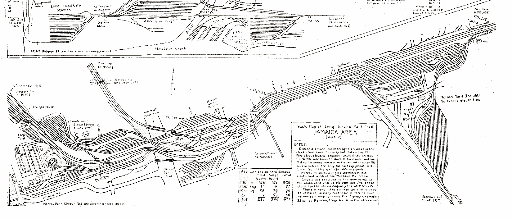
There's a building on the Atlantic Branch east of the dairy just before the first big curve east of Hall that has a sign on the rear saying "Ideal Steel". They landscaped the wilderness that used to be in the back and actually starting to fix up the old ramp (earth berm) that once held a looooong-abandoned siding from the elevated tracks down to ground level. Now, I know the fellas don't do the Atlantic Branch, and that there's almost no chance ever, of a siding going in... But, it's almost like they're prepping for it. Anyone?
  by freightguy
 
Ideal steel received cars in St James team track on the Port Jeff. I don't know if this is the same comapny that's in Jamaica....
  by The Tenth Legion
 
The St. James customer that received structural steel in gondolas and bulkhead flatcars got banged in the dumper when NYA decided to end service east of Greenlawn. It's too bad. Until recently, NYA seemed to be willing to go anywhere to serve anyone, be it once a month or everyday, trying to grow their customer roster. Maybe in the not-too-distant future, better times will make renewed NYA service to points east of Greenlawn worthwhile.
  by Sir Ray
 
I was just reading the Strourbridge line thread in the Pennsylvania forum, and saw Ideal Steal mentioned as owner of the Stourbridge line, and a potential rail freight client along that line
the new owner, Paul Broncatta of Ideal Steel on Long Island, NY
.
BTW, are you talking about the lot south of Liberty Ave., by 157th - I do remember a siding years ago which descended to ground level, and formed a switchback - the siding was removed (late '90s? perhaps), and I think they torn down some of the former buildings, and build a new one over the years since, but I don't remember any further work on the siding embankment (although I haven't been that way for about 5 months)
  by BobLI
 
Sir Ray,
Yes thats the siding, it used to service a coal company there. I believe it was taken up in the 70's when the coal company went out. The silos were standing for a few years after that until they were torn down. I dont remember a switchback there, but there was another building on the same siding that had tracks in back of it that were long overgrown. That building was where the empty lot on the corner is now. It sure did look like they would put a new siding in when they cut down all the brush on the ramp up to the main tracks, but I think that was part of the brush/tree cleanup from Jamaica to Laurelton.

In addition the Steel company had some "artwork" from the local youths on the back of the building but they quickly covered that up. And it hasnt had any since then. Wonder how they persuaded them not to go in back of the building? A few dogs at night?
  by Sir Ray
 
BobLI wrote:Sir Ray,
Yes thats the siding, it used to service a coal company there. I believe it was taken up in the 70's when the coal company went out. The silos were standing for a few years after that until they were torn down. I dont remember a switchback there, but there was another building on the same siding that had tracks in back of it that were long overgrown
No, it can't be the same location then - the siding (which was definitely a switchback) was there at least into the late 1990s, if not later (I saw it myself) - the ramp down to grade came off the West side of the line, and headed North. Also there were no coal silos, though they could have been torn down well before that. Here's (a somewhat outdated) a Live Local view of where I was thinking about (BTW, Live Local seems to be acting up again in my IE browser, continuing polling and not letting me pan over the map correctly) - there's at least one (newish) building on that lot (I think), and you can kind of see the ramp for the siding down to grade level.
  by BobLI
 
Sir Ray,

Thats the spot I was talking about when I pulled up your map. I've been passing that spot riding the RR since 1965... There was a coal yard there and there was a track that continued to the next brick building which both were demolished. The brick building had large trees growing up in the tracks before they tore everything down.
The siding was out way before the 1990's. In fact i think it was out before the 80's. The ramp is still visible going down the west side of the track embankment. I even remember coal cars there when the siding was in use.

Any members have a track map of that area by south road (JJ Earl)? That would clear up the confusion about a switchback.

All I remember is a track going down to the coal yard and another track going further north to south road. The track toward south road was OOS a long time when I started seeing it. It may have had a switch before the coal yard unloading pit but when I saw it it was cut and OOS. I only remember seeing the one track go down the ramp to the coal yard being in service.
  by Sir Ray
 
I'm sorry, but that does not jive with my memory at all - yes, there was another brick building on that lot (and quite possibly silos, but those were gone way before I was paying attention), and the building that was torn down was adjacent to South St. - the track came down the embankment (headed North) and then the switchback was where the embankment ended, the tail headed north to the torn down building, and the other leg headed south (of course). I was heading a lot into Manhattan during the mid-late 1990s, and that's when I noticed it (when they removed that track I can't be sure - if you said turn of the century I'd say that's a good guess) - I definitely did not notice it before 1995 (actually I rarely took the LIRR before then). I did notice a lot of interesting things, including the two very short trestle stubs in that area (one Northward toward the Dairy, and one Southward toward the School Track/Field), and of course the switchback/embankment (which was definitely covered in vegatation then).
And yes, I was a little intriguied when they cleared really the land, but by then it was Bloombergland, where building anything besides unsalable overpriced condos and third-rate big-box retailers is verboten...
  by BobLI
 
Ray, we need some one with a track map of the area to clear this up... Maybe my memory is playing tricks on me.... its been a long time since i saw the coal silos and track.

And i enjoyed the discussion, thank you!

yes bloomie sure did mess up downtown brooklyn too, Empty condos as far as you can see!
  by Sir Ray
 
Apparently, according to this map of Jamaica from Trains Are Fun, we're both wrong :P - nothing came off the Atlantic Branch at all in 1950.
Of course, since those siding & trestles did exist, it just tells me that this map is not detailed in that area (perhaps because the Atlantic branch was covered in a different map inset).
I would envision the spur layout looked similar to the one off the West side of the Montuak Branch on that map, south of Liberty (give or take a few spurs), and eventually the spurs were dismantled until only a tailback and a south facing track were left.
  by Sir Ray
 
Nobody get excited - but there has been what looks like recent construction at Ideal Steel at Jamaica (at least to me, since I don't take the LIRR every day - maybe this was built last year). There is now a large corrugated fence surrounding the land behind Ideal Steel (track-side). Inside this sizable fenced-in yard there is a steel structure, perhaps still under construction (it is in primer red), perhaps finished, either a rack system of some sort, or if you squint really hard, an overhead travelling crane system of some type. What is interesting is a) there is a large gate on the south side b) there didn't seem to be a driveway coming out from this gate. NOW, if this WASN'T BLOOMBERGOPOLIS, if this WASN'T the LIRR MONTAUK LINE, and if the freight franchisee WASN'T NY&A, then the answer would be simple - New Rail Freight customer coming, using the ROW of the former siding that was once there (and which lines up nicely with the new gate). BUT, it is fact that all three of those things are true, so my guess is that Ideal Steel will build a driveway East from the end of 107th Avenue, curving into this new yard via that gate, and are simply waiting for permits to clear, so they can eventually unload flatbed trailers in back (which does make sense).
1) Don't bother with Bing or Google Maps - their views are out-dated and show no such construction.
2) I had only about 30-35seconds to view this, so some (all?) details may be incorrect. But the basics are: Fenced in yard; Large Steel structure (racks?) in primer red; Gate on south side of yard, in the direction of the former spur; no obvious driveway from 107th to gate. And I don't recall this from last year (at least not the steel structure - it seemed for internal usage, and not some client product)

Any actual knowledge out there?