WOOHOOO!!!
I don't know what compelled me to check for any new maps today, but to stumble on to you guys talking about the electric line through Strykersville and Java relit the fire under my butt on this project.
I grew up in Strykersville, and asked my grandfather about the outcropping in the neighbor's back yard one day. He explained that a railroad had been graded, but never installed. Since then, I have collected maps (same as the ones posted here), and hiked, rode, and argued frequently about the existence of such a proposed line. Some of the sections of bed look like the railway was pulled out recently (even though there was never rails there in the first place).
I have had maps covering the entire line through Sheldon and Java, and I have followed much of the route there. Most of the level parts of Route 78 were rail bed at one time, and most of the homes along those sections never popped up until AFTER 1900, after the railbeds reverted back to the original owners, after the Buffalo Attica and Arcade Railroad went belly up (evidenced on title search entries along the route - I'm a Real Estate Broker

).
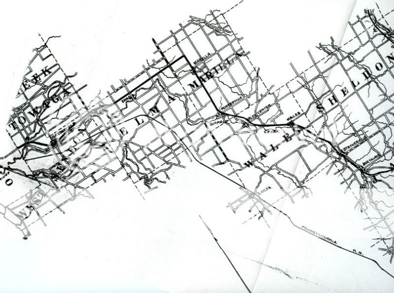
The biggest problem I reach is trying to figure out the route of the railway once it enters Erie County, particularly around Merlau Road. However, last year, I met a good friend of my boss who lives on Merlau Road. When I mentioned the railroad line (totally out of the blue, catchi9ng him by surprise), he had no idea what I was talking about. After a minute of explaining that it followed the Route 78 current roadbed until just before Merlau Road, and that THAT was where I lost it, it was like a light went on. He explained that when he did the site survey for his home site, his excavator insisted that a section across his property and going deep back into the woods behind it had a raised rail bed. The property owner didn't quite grasp it, as no railroad had ever been installed, so he had no knowledge of any railroad.
I hope to make it over there this summer to check it out. It will also let me fairly accurately plot another 1/4 mile South of his property, and the line will be completely tracked from Route 98 (where it met up with the LVRR/A&A) to *hopefully* Route 78 NORTH of Woodchuck Road.
I did see the previous post with the map plotting the route into Erie County, which seems potentially accurate North to Porterville, but the route North to Marilla would have been nearly impossible, because the train would have to climb out of the ravine where Porterville's mills were. I had an almost heated argument years back with one of the gents from the WNYRHS who insisted that the entire route was impossible due to elevations and slopes. When I brought him my map collection, he cordially apologized when he saw that it was an electric railroad, because they could climb higher slopes than any other previous designs. However, the slope North out of Porterville would have been too much.
I have had this 30+ year old project on hold for the last 10 years or so, except for the occasional search for new (old) maps online. I just stumbled on to this thread today. If anyone would like to collaborate on this, LET ME KNOW! Ultimately I would like to GPS track the entire line, maybe even get started this Summer.
I'll check back next week when I will have time to read this thread more carefully. In the mean time, I am setting this up so I receive notifications if anyone replies here. So feel free to holler if I can help, or if you have anything to add.
Jason